Canada’s western rivers served as the major inland travel routes for the 18th and 19th-century fur trade. Then, later, their banks were covered by prairie cities – Edmonton, Calgary, Medicine Hat, Saskatoon, and Prince Albert.
The distances the early traders travelled in their flimsy-looking, but effective, birch bark canoes were legendary. Imagine, along with your seven companions, starting at the Grande Portage on Lake Superior. For the next 40-60 days you paddle 40-45 strokes per minute, first downstream, then upstream, to reach Fort Edmonton. Hopefully, you will arrive, after covering over 1,600km, before freeze-up.
Last summer, Mike Donnelly canoed one of these rivers. Unlike the early traders, his was a shorter, less strenuous, solo adventure. Mike set his canoe in on the Bow River near Bassano, Alberta, Canada. He canoed east down the South Saskatchewan River. Finally, after 41 days, he ended his journey east of the Forks of the Saskatchewan. The distance following the river, if driven by car, is nearly 700km. By canoe, it’s 1,228km.
Here are a few stories Mike collected on his travels. The numbers on the map below correspond to the numbered places on his photographs and titles.
The Saskatchewan River Drainage, western Canada
Postcards From the Saskatchewan: Mike Donnelly
1. Day 2 – August 7th – Bow River
“The Prairie proper ends at Calgary, among the cattle-ranches, mills, breweries, and three million acre irrigation works. The river that floats timber to the town from the mountains does not slide nor rustle like Prairie rivers, but brawls across bars of blue pebbles, and a greenish tinge in its water hints of the snows.” (1907, Rudyard Kipling travelling west on the CPR) 1
I put the canoe in two hours east of Calgary, below the Bassano Dam. The Bow no longer brawls over pebbles here, but slides and rustles like a prairie river should. I didn’t step onto a sand bar for ten days; not until the Alberta border, at the Forks, where the South Saskatchewan and the Red Deer Rivers meet. Until then, it was just sticking, slipping, sliding, squishing—mud.
2. Day 5 – August 10th – South Saskatchewan River
The drilling crew struck gas in January of 1909. They called the well Old Glory. It was the largest producer in the country and the beginning of the Bow Island Gas Field. By 1912 a pipeline was completed running 170 miles 2 up to Calgary, and 12,000 people gathered on a summer’s evening to watch the lighting of the inaugural flare. 3
Gas Town had been just upriver from where I was camped; a little village of company workers and their families. By the 1930s, there was a double row of houses, vegetable gardens, green lawns, and hedgerows. There’s nothing there now, just prickly pear and prairie grass. Setting up camp, I had to watch where I stepped, and still ended up pulling a few cactus spines from my foot. The wind began after midnight and was soon battering the walls of the tent. By morning, all was calm again.
3. Day 6 – August 11th – South Saskatchewan River
It was a cow that woke me up. It woke me from my bent-up, mid-afternoon siesta in the bottom of the canoe where I’d grounded along the shore. I lifted my hat and looked down at the bleached exoskeleton of a dead crayfish just under the water. I looked around, there was no cow, it was dream-cow, I was starting to dream cows now.
Later, I was told this ruin was the old Wallwork ranch house. They had come east from Lethbridge and, before that, England. In photographs, Nathan has the confident mien of a riverboat gambler. Rachel looks like a sturdy and imposing woman. She’s draped in a long dress with ruffled sleeves. A wide hat, like a fancy gateau, sits perched atop her head.
In the spring of 1903, a railway car carrying all their possessions was dropped in the siding at Cherry Coulee—a lone box car on the open prairie. Everything (including an organ, for Nathan was an accomplished pianist) would be unloaded and carried by wagon down to their new home by the river.
I picked up the handle of a porcelain cup. In the next room the floorboards were falling through to the cellar and canvas scraps, still clinging to the walls, fluttered in the breeze. Outside in the grass, I stepped over the bottom of an old shoe and kicked at a tin can. Rusted bed springs had been stuffed down the well. Kingbirds chattered and flitted from the cottonwoods to the sagebrush and back again.
4. Day 8 – August 13th – Medicine Hat
I watched the old green bus drive away, ‘Watch More Sunrises’, counseled the bumper sticker. I’d lost my wallet, and now my ride into town. The family was from a northern Ontario railway-turned-lumber-turned-mining town. There were solar panels on the roof, four bicycles hung from the hood, and inside was a full fridge, home-made cabinets, a table, and bunkbeds. Dad pointed at the passenger seat, “Found that at the dump, it’s from one of those three-wheelers for handicapped people.” They seemed real nice. I was sad to see them leaving without me.
Later, after having found my wallet, my way into town, and stocked up on supplies, I took a taxi back. Debbie, driving, pointed out the historic barn with its rounded gambrel roof, white clapboard, and brown trim:
“I had to paint that barn one summer, as punishment.”
I assumed underage drinking.
“No, I hit my sister in the mall.”
“And your parents punished you?”
“No, the cops saw. The judge was hard on me; he also gave me a $500 fine.”
“Wow, you must have really decked her.”
It was 37 degrees out, the small lake was full of kids, and there were signs warning of Swimmer’s Itch. I walked a mile back to the campground and followed my shadow the entire way.
5. Day 15 – August 20th – Lancer Ferry
The crickets buzzed all afternoon. In the middle of the river I passed a rattlesnake; head up and sidewinding its way over the brown, choppy water. By six o’clock, I had tied up at the ferry landing, a 54-kilometre day. The guys at the last ferry had called ahead and warned of my approach. Dinner was ready: corn on the cob, homemade sausages from the air-fryer, and a beer. Our phones all sounded the alarm at the same time:
“Emergency Alert. Severe Thunderstorm Warning, 8:08 p.m. DESTRUCTIVE WINDS in this mobile coverage area. Take immediate cover in a basement or interior room if weather threat approaches. Shelter from flying debris if outside.”
I sheltered in the Ferrymen’s shack. There was nowhere else to go. Back to the Future was on the T.V. and the rain came down hard on the roof. We missed the worst of it, and the dark clouds soon passed away to the southeast, while the mosquitoes reappeared.
6. Day 21 – August 26th – Lake Diefenbaker.
It was just after 9 am, and with the tickle of a breeze behind my ear, I raised the sail. It wasn’t much, but I was moving. Soon enough, I was becalmed again. This was usually the case, or else the wind was in my face. Which was fine, I guess; I had been told stories about the wind and waves on Lake Diefenbaker. Leaving the town of Elbow at the head of the lake I passed a man on the beach with his dogs: “You picked a good week, these last six days. Usually, it’s windier than hell out here!”
I missed the cows and the beavers. I missed the talkative kingbirds, the nighthawks, the herons, and the soft sighs of the doves in the cottonwoods that lined the riverbank. There were no more robins, or peewees, or warblers. This was a 200-kilometre-long reservoir; there was no riverbank, there were no trees. Perhaps the songbirds had all flown south anyhow. Most of all I missed the current. At noon, I went for a swim—It was hot, hot, hot. Then I crawled ashore like a castaway, dragged myself into a tumbledown lean-to made of driftwood, and hid from the sun.
7. Day 34 – September 8th – Fish Creek
The breeze was out of the north and carried the hint of forest fire. The crickets were waking up, and a catbird mewed from the caraganas. There were starlings perched on the cross atop the steeple, pigeons strutted along the roofline, and flapped in and out of the gaps in the louvered shutters. The Church of the Immaculate Conception—Prairie Gothic. Father Brueck spent the summer of 1900 travelling, living in a tent, and ministering to groups of Métis and Galicians (Poles and Ukrainians). By winter, they had built him a log shack. In a letter to his superior, he wrote:
“Last Sunday I celebrated mass for the first time in the chapel. It is far from being finished. Roughly plastered with mud, it looks more like a barn than like a chapel residence. But our Lord did not disdain a stable at his birth.”
The church was built the following year. In 1920 it burned, was rebuilt, and then closed permanently in ‘57. To put off vandals, Jack Bozowski bought the church and the land. He planted wheat up to the walls and was quoted as saying,“If people do not respect old buildings there are still some who respect a crop of grain.”4
8. Day 37 – September 11th – South Branch House
“The men were all French Canadians with long red or blue caps, half of which hung down the head; they wore grey capots, or blanket coats, belted round their waist, their trowsers of grey cloth or dressed leather, and their shoes of the same. Our dresses were a coarse hat, tight blue jacket with leather trowsers and shoes, to which in winter was added a leather coat. We now cleared the ground to build a log house of thirty six feet in length by twenty in breadth, which when carried up to seven feet in height, was roofed with split logs, the ridge pole was placed on two upright Logs of twelve feet and gave to each side a slope of five feet. The whole was mudded and covered with earth.” (the building of South Branch House, from David Thompson’s, Travels) 5
The four canoes of HBC men arrived on the 28th of September, 1786. 6 A young Thompson spent the winter here, working as a clerk. Eight years later, South Branch House was pillaged, burned, and never rebuilt.
As I approached, the crows were streaming from the tops of the aspens that lined the high bench, flying away to the south. A ruckus of black birds. I counted one hundred, two hundred. The bank was steep, and I had to scramble up (and returning, fell my way down). The trees were still green, but the dogwood willows were a deep red, and the chokecherry leaves were turning to rust. The berries were ripe: black, sweet and furry on the tongue. An oat field of golden stubble stretched away to the east.
The bench led down to a flat, and in 1885, this was known as Gariépy’s Crossing. There is a photo of Riel taken here at General Middleton’s camp, following his surrender in the days after Batoche. He stands with his hands in pockets against the corner of a canvas tent, perhaps talking with someone out of frame. Bearded, dark vest, battered cowboy hat. He seems at ease. The soldiers stand a polite distance away with the river behind. Six months later, he was hanged.
9. Day 37 – September 11th – St. Louis
“One had to pass through the French settlements, after these sad events, in order to fully perceive the mourning and desolation that reigned there. I went to St. Louis around that time and, even if the enemy had not passed through there, even if there were no incinerated houses, the sight of all those sad and dejected faces, of those widows whose husbands were dead or in exile, of those wounded, lying inert and in pain, gave me the most intense impression of sorrow. And all these people had hardly any food left.” (Louis Schmidt) 7
It was 52 days by ox-cart from Red River when the first large group of Métis settlers arrived here in 1882. In 1870 Louis Schmidt had served as Riel’s personal Secretary in the Provisional Government at Red River. By 1885 he was working as an Agent of Lands in Prince Albert. He supported the Metis grievances but took no part in the rebellion:
“He condemned the recourse to arms and apostasy of Métis who had followed Riel in his heresy.” 8
As I paddled towards the bridge, I could make out, ‘CAR WASH’ through the tree tops, in bold, red-faded letters. On the far side of the river was a tumbledown yard and a barking dog. It felt humid and swampy. I pulled in to shore and spooked a flock pigeons out from under the bridge. A group of wading yellow-legs pew-pew-pewed away across the water. I was hoping to stop in at the old riverside hotel for a drink and something to eat. I’d sit with my elbows atop the well-worn countertop, and the bartender would ask, “You come up from the river?” (A canoe-trip is currency in any conversation.) Then, I would ask about the story of the Ghost Light of St. Louis. A Pepsi sign still hung out over the front door, but the hotel was closed. A crushed-gold-velvet swivel rocker sat out front on the sidewalk. It looked like it had been closed a long time. I never did get the story.
10. Day 41 – September 15th – North Saskatchewan River
I sat cross-legged at the tent door and watched as one star appeared, and then another. I looked away, and when I looked back again the northern lights had come—soaring, needle-like columns that hung low over the water—pale-green and luminescent. A curtain of glowing light that drifted and shapeshifted across the eastern sky. Then, after twenty minutes they were gone.
This was the time of the Goose Dance, Niskisimowin, of the Muskego (the Swampy Cree of the Hudson Bay lowlands and the lower Saskatchewan). 9 The traders called it the Rendezvous.10 It occurred in the spring and the fall, at gathering places along the river, with days of feasting, dancing, and ceremony.
“Each spoke addresses to Kitche Mantiou (The Great Spirit), thanking him for the gifts of food and supplies to his Indian children. Each of the winds were given a smoke by presenting the pipes to the four quarters of the compass. Then with a stately walk around the old men retired. The tomtoms struck up and four young girls came dancing into the ring each with a bag of down of fine feathers. Keeping time to the music as they circled, a bunch of down was placed on each visitors head. There was a pause and then bang went the tomtoms at full speed.” (Reginald Beatty, Hudson’s Bay Co. trader, 1870s) 11
It was my final morning and I paddled for five hours in the fog, sometimes unsure if I was pointed upstream or down. I heard wolves; a long, low howl that carried across the water, followed by another. Ten minutes later I rounded a bend and they started up again, all of them, right there, somewhere, in the fog and the spruce along the riverbank. A descending chorus of howls and song. And then suddenly, silence.
Footnotes:
Kipling, Rudyard. 1920. Letters to Family, from Letters of Travel: 1892-1913. Doubleday Page & Co. New York, pg. 197.[↩]
Petroleum History Society Archives: November 2002; Vol XIII, No. 5.pg. 2.[↩]
Lavigne, Solange. 1990. Kaleidoscope – Many Cultures, One Faith : the Roman Catholic Diocese of Prince Albert, 1891-1991. Diocese of Prince Albert, pg. 193.[↩]
Hopwood, David, Editor. 1971. David Thompson – Travels in Western North America 1784-1812. Macmillan of Canada, Toronto, pg. 86.[↩]
Moreau, William E. Editor. 2009. The Writings of David Thompson, Vol I. The Champlain Society, pg. 53.[↩]
Lavigne, Solange. 1990. Kaleidoscope, Many Cultures-One Faith – The Roman Catholic Diocese of Prince Albert 1891-1991. Published by the Diocese of Prince Albert, pg. 170.[↩]
Lavigne, Solange. 1990. Kaleidoscope, Many Cultures-One Faith – The Roman Catholic Diocese of Prince Albert 1891-1991. Published by the Diocese of Prince Albert, pg. 514.[↩]
Meyer, David. The Goose Dance in Swampy Cree Religion. The Journal of the Canadian Church Historical Society. Vol. XXXII No. 1. April, 1991, pg. 107.[↩]
Meyer, David & Thistle, Paul C. Saskatchewan River Rendezvous Centers and Trading Posts: Continuity in a Cree Social Geography. Ethnohistory, Vol. 42, No. 3. Summer, 1995, pg. 403.[↩]
Meyer, David. The Goose Dance in Swampy Cree Religion. The Journal of the Canadian Church Historical Society. Vol. XXXII No. 1. April, 1991, pg. 111.[↩]
Note: The author presented a version of this work as a keynote presentation at the 49th Annual Alberta Archaeological Association Meetings, Drumheller, Alberta, Canada, 2024.
“The prairies over which we travelled presented the same undulating, monotonous appearance.…To add to our discomforts on this day’s march, old Welsh, the guide, lost his bearings and led us miles out of the way. Indeed, for a considerable time we followed no track at all and were at the mercy of the Métis.” — Canadian Artist, Henri Julien, travelling west across the Canadian Prairies with the newly formed North West Mounted Police, 1874
The North West Mounted Police (NWMP) near the beginning of their trek west. Sketch by artist Henri Julien. He accompanied the police over endless stretches of Prairie. They traveled into what would become southern Saskatchewan and Alberta, Canada.
While researching our recently published book, Cartographic Poetry. Examining Historic Blackfoot and Gros Ventre Maps, 1 I became interested in Indigenous wayfinding (the process or activity of ascertaining one’s position and planning and following a route) and navigation skills. 2 Compared to the Blackfoot, I realized that our current society has lost much of its natural ability to navigate through space. Where would we be without roads and signs, maps or GPS systems to guide us wherever we wish to go?
LOST!
In our book, we examine four Blackfoot and one Gros Ventre map recorded in the journals of Hudson’s Bay Company trader and surveyor, Peter Fidler. Fascinated by these maps, I have delved deeper into Indigenous navigation and wayfinding. 3
Imagine traveling across the vast, empty, and often featureless Canadian prairies or Arctic. Picture doing this hundreds of years ago. You would have no map, road, or GPS for guidance. How would you know where you were? How would you navigate across a barren landscape without any of these devices? In this blog, I will first explore how humans navigate. Then, I will investigate how North American Indigenous People navigated their prairie (and other) landscapes. 4
Part of my inspiration for this work came from reading a book written by M. R. O’Connor, entitled Wayfinding. The Science and Mystery of How Humans Navigate the World.5 I recommend this work to anyone who wants to dive deeper into this fascinating topic. I borrow examples from O’Connor’s work to place our Canadian Indigenous maps into a broader framework.
M. R. O’Connor is a journalist who has conducted extensive research, including fieldwork, on wayfinding in the Indigenous world. What I appreciate about her approach is her treatment of the work as journalism. She provides the reader with all relevant theories and viewpoints. Some of these are controversial, and she includes them from a wide range of disciplines. This allows readers to decide their validity.
How We Find Our Way Around
We don’t need to concentrate much when navigating through spaces we’re familiar with. However, when we travel greater distances and into unfamiliar territory, negotiating becomes more challenging. We have developed new technological devices. These devices help us navigate through unfamiliar spaces. They guide us to our desired destination effectively with little effort. We no longer need to plan and memorize our routes. Our instruments do that for us.
As a teenager in the 1960s, I lived in southwestern Saskatchewan, Canada. I would often explore the prairies on my dirt bike. Occasionally, I motored into the sand hills northwest of Cabri, Saskatchewan. I was soon surrounded by an endless set of similar-looking dunes, with no roads or tracks to guide me. Also, when out on the vast prairies, where often there are few landmarks, everything begins to look the same.
For a few moments, I realized I was utterly and totally lost.
My moment of panic at my predicament didn’t last long. With a few simple observations, I managed to find my way back.
Indigenous people throughout the world, on either the land or on the oceans, can’t afford to get lost when navigating their territories. Survival depended on knowing where you were or how to find your destination at all times.
In her book, O’Connor documents the early Polynesian’s profound knowledge of their watery environment and celestial navigation skills. “Seafarers might estimate their latitude and direction by looking at the positions of the stars, particularly those near the horizon in the night sky. The 32 principal stars and various secondary stars that made up the star compass served as a framework for navigation. This complex information enabled navigators to plan their course and make changes in response to the shifting positions of the stars throughout the course of the night.”6
What amazes me is the size of the territories Indigenous people navigated and their detailed knowledge of their surroundings. Take, for example, the Blackfoot Indigenous maps that I will explore in detail, as well as the size of the territory in question. Ki oo cus (a Siksika leader) drew a map for the Hudson’s Bay Company trader and surveyor, Peter Fidler, in 1802. It stretches as far north as Buffalo Lake in central Alberta, Canada. It extends down to the northern parts of Wyoming, USA, covering an estimated distance of 960km. Additionally, it spans from the Rocky Mountains to Manitou Lake in southern Saskatchewan. This distance is approximately 707km. The total area then would encompass a mind-boggling 678,720 square kilometres.
Can you imagine being at the fur trade post Chesterfield House (near the confluence of the South Saskatchewan and Red Deer River)? Picture yourself drawing a map of some key landmarks of this vast territory for Peter Fidler. How did Ki oo cus and others achieve this feat? How did he lead his band to the places they needed to be during certain times of the year? He had no maps. He kept all the knowledge of his territory and the landscape in his head.
These are the five maps we explore in our book. Some of the other maps encompass an even larger area than Ki oo cus’s map. These areas were not all part of these leaders’ traditional territories. They were places known to them or that they visited. The Ki oo cus map, for example, shows the travel routes his people took. This suggests they travelled as far south as the Judith Mountains in central Montana, USA. Some of them also travelled as far north as Buffalo Lake in central Alberta, Canada. 7
Three of the Blackfoot maps that cover parts of Canada’s Alberta and Saskatchewan (top) and modern renditions of the territories and places those maps encompass (bottom). From left to right: First, one version of Old Swan’s (Ac ko mok ki) map, 1802. Then, Ak ko wee ak’s map, 1802. Lastly, Ki oo cus’s map, 1802. 8
How Humans Navigate
How did humans, without today’s navigation aids, find their way around?
This somewhat controversial, complex topic touches many disciplines (genetics, otorhinolaryngology/physiology, psychology, geography, anthropology, and neuroscience, to name a few). It focuses primarily on one major part of our brain – the hippocampus (Greek for “seahorse” because of its shape), also known as the Horn of the Ram. This part of the human brain is primarily responsible for memory. It also facilitates learning and spatial navigation. I like to think of it as the area in our heads where memory happens, and navigation begins.
The hippocampus has special cells that store certain types of spatial information to help us navigate. These include: 1) Head-direction cells, which store the direction your head is pointed; 2) Place cells, which store landmarks, linear speed, and other spatial information; 3) Grid cells, which store information about space and distance; and 4) Border cells, which store information about distance and direction from a boundary.
Diagram on the left showing the location of the hippocampus, responsible for memory, and also other parts of the brain responsible for other functions. The photograph on the right of the hippocampus and the seahorse, showing the resemblance in shape between the two.
The size of the hippocampus in humans varies. For years, scientists believed that genetics determined the size of the hippocampus. This explained why some people had superior memory. It also explained why they could navigate better than others. That myth was shattered in 2006 when researchers 9 studied the hippocampus of London taxi drivers (who possessed vast spatial knowledge of London’s streets and neighbourhoods). They found that taxi drivers’ hippocampus was larger than their control group, larger in taxi drivers with more experience, and larger than that of bus drivers.
London taxi drivers must pass very stringent navigational tests before acquiring a taxi license. 10. The taxi study suggests that the hippocampus can expand if this part of the brain is active. What other studies also suggest, and is somewhat frightening, is that if not used, it will contract.
According to experts, if you don’t use the hippocampus to store certain types of memory information necessary for navigation, it can shrink. Relying solely on your mobile devices for navigation contributes to this shrinkage. That’s a scary thought, given how reliant we’ve become on our phones and GPS to guide us to our destinations.
Principles and Mechanics of Wayfinding and Navigation
A clear conscience is the sure sign of a bad memory.” ― Mark Twain
How does our brain process spatial information to find our way?
Have you ever walked through an unfamiliar city, park, or shopping mall? Have you then tried to retrace your steps back to your car? If you managed to find your way back, how did you do it?
Venice Italy. A City often called The Labyrinthine City because of its narrow, winding streets and canals, making finding your way or destination a real challenge. When I first visited Venice in 1971, we only had maps to guide us. Even with maps, we carefully noted the surroundings of our lodgings and memorized our routes so that we could find our way back again. When I visited in 2024, this was no longer a problem. With a phone GPS, you set your location and plan a route to a destination by using your GPS guide. 11
There are two theories to explain what is involved in human wayfinding and navigation: 1) Practical Mastery Theory – orientation in space is based on the experience of individuals in particular environments; and, 2) Mental Map – stored spatial information in the form of a mental map, and inferred information. Both theories have their supporters and detractors.
Route Knowledge, as part of Practical Mastery Theory, is the ability to construct a sequence of points, landmarks, and perspectives that make up a path from one place to another. The traveller uses a string of memories of landmarks or viewpoints to recognize the correct sequence for getting from one place to another. The traveller also must remember that at a particular landmark, they must turn a certain direction (i.e., left, right, east, west, etc., or continue straight ahead).
With Survey Knowledge, an element of the Mental Map, the traveller mentally organizes space into a stable, map-like framework, in which every point or landmark has a two-dimensional relationship to every other point. According to O’Connor, “While route knowledge is the verbal description you might give when telling a friend how to get to the post office, survey knowledge is the “bird’s-eye” map of the walk you might draw for that friend on a piece of paper.”12
I’m torn on the topic. I can imagine a mental map where I place certain places in space in order, relative to one another – landmarks, if you will, to help me get from point A to point B. I also agree with sociologists and anthropologists. They suggest that the wayfinder relies on visual memory. The wayfinder is immersed in cultural practices, habits, and knowledge. Direct perception of their environment helps reinforce that memory. This process aids in navigating and finding their way. 13
There’s certainly a lot of empirical evidence in support of both theories, which require a heightened awareness for spatial observation. According to famous Australian aviator Harold Gatty, “With nature as your guide, you need never be lost.” Gatty further believed that Indigenous Peoples (Native Americans, Australian Aboriginals, Polynesians, Inuit, Europeans, and Saharan nomads, etc.) had “…keener perceptions and more highly developed powers of observation than most of us…”
Gatty used a compass and other navigation instruments to help guide him on his long aerial journeys. However, he was also very interested in how Indigenous Peoples navigated. In his 1958 book, entitled Finding Your Way Without a Map or Compass, Gatty maintained that environmental pathfinding observations were only intended to supplement, never supplant, the use of a map and a compass. But Indigenous people didn’t have compasses and maps to guide them. So how did they manage to navigate accurately, often over thousands of miles?
Peter Fidler’s Blackfoot informants, who drew him maps of their territories, possessed route knowledge. They also had a certain amount of survey knowledge. This enabled them to find their destinations along a planned route. They used landmarks and other environmental indicators to guide them. They also depict those landmarks relative to one another in two-dimensional space (more on this topic later).
WHAT WOULD YOU DO WITH A MAP IF YOU HAD ONE?
WHERE AM I? According to current research, a significant portion of the present population struggles with traditional map-reading skills. This is largely due to reliance on GPS and smartphone navigation apps. 14 Outdoor guides and military personnel have found that a high percentage of the general public struggles with orienting a map, using a compass, or interpreting topographic lines. Younger adults (18-24) are the most likely to rely exclusively on smartphone apps for navigation (83%).
Humans also use different methods of orientation, which are often culturally dependent, to help them navigate. The use of an Egocentric Perspective of space requires the individual to orient everything in space, relative to themselves (i.e., front, behind, up, down, left, and right). An Allocentric Perspective of space is more objective and map-like. Individuals place objects and landmarks relative to one another in their spatial locations. As a general rule, Indigenous cultures use an allocentric perspective while industrialized cultures use an egocentric perspective more often.
Different spatial frameworks for organizing and navigating space and time. E.G., INDUSTRIALIZED SOCIETIES – LEFT-RIGHT MENTAL TIMELINE (EGOCENTRIC). E.G., INDIGENOUS CULTURES – ABSOLUTE (ALLOCENTRIC) FRAMES OF REFERENCE – EAST = PAST; WEST = FUTURE. Imagine using an egocentric perspective to find a destination and then return home. Once you turn around and go home, everything is reversed. When going to your destination, objects or landmarks were on your right side. When returning, these objects or landmarks are now on your left side. This reversal often disorients individuals and leads to eventually getting lost. 15
Before examining our Blackfoot maps more closely and what they tell us about wayfinding and navigation, let’s examine some examples of the methods and cues humans use(d) to find their way around.
On Safari – 2022, Inyati Game Preserve, South Africa
In South Africa, I am on Safari at the wildlife sanctuary near Kruger National Park. I am with six other people in an open-roofed lorry. We are driving through the countryside and admiring the wildlife. At the end of the day, our driver drove quickly through the African bushland. It was total darkness as they navigated back to our lodge for the evening. I was totally lost. But my guides were not, despite not using any GPS equipment. Only their acute knowledge of the seemingly endless trails and a keen sense of direction guided them. This was a good example of practical mastery theory of navigation and route knowledge. These men memorized thousands of minute details on the landscape. They used keen observation to help them decide where they were at any given time. This also aided in choosing the trails needed to return to the lodge.
The Inyati Game Preserve in South Africa covers approximately 650 square kilometres. A major river and a lesser stream run through it. There are some hills, but very few other landmarks. A maze of trails runs through the bush, leading to various places on the preserve (top photograph of the location of the game preserve and trail system). Upon first arriving, once we left the lodge, I was totally lost in this wilderness and would have had a hard time finding my way back, even with well-worn trails. But after a few days, as we repeatedly drove over the same trails, I began to notice subtle landforms or objects which helped me distinguish one trail from the other. After a while, I knew that if I could find the river, it would eventually lead me back to our lodge, provided I went in the right direction and didn’t get eaten or trampled by the wildlife.Even in the dark, heading back to our lodge, our local guide and driver, George, always knew the way. I remembered then. In parts of my misspent youth, I barreled down the country roads on the very flat Saskatchewan prairies in the pitch dark. The many road crossings often looked the same to those unfamiliar with the area. But we were never lost, memorizing the many little details of our surroundings to help us find our way.
Songs and Stories Hold Our Memories
Wayfinding and navigation often involve memorizing a long sequence of places or landmarks in the right order of their occurrence along a route to another destination. Human cultures have devised ingenious ways to help them not only memorize but also keep everything in the right order. Many Indigenous cultures, including the Blackfoot, used songs and stories to remember places on the landscape.
Linguists and musicologists believe we retain details better in songs and stories. This should be a familiar concept even for our present societies. Remember how you learned your ABCs with that little song that went with it.
“By embedding story in landscapes and the actions of ancestor beings, the Aboriginal oral tradition of songlines is strikingly similar to other oral traditions—the ballads, epics, and children’s rhymes found in places like Ireland, Yugoslavia, ancient Greece, and numerous folk traditions.” — M. R. O’Connor
According to O’Connor, “In his book Memory in Oral Traditions, the cognitive neuroscientist Rubin thinks that oral traditions developed to avoid the weaknesses of human memory, which more easily records scenes rather than abstract knowledge. And these traditions utilize another strength of our brains: using rhythm and music to cue memory. Consider how many of us learn the alphabet as a child by singing it. With some practice, the notes become bound to the letters, the mind to recall them with ease.”
The Australian Aboriginals took song and travel one step further. They travelled across the continent with their songs and the night sky to guide them. To some neuroscientists, wayfinding resembles a song, which is temporally structured, as is travel.
How far back do the stories and songs go in Australian Aboriginal oral history? Some stories may go back 13,000 years. 16
According to Luise Hercus and her colleagues, stories about features and places on the landscape give “…deeper significance to ordinary geography and make it more memorable.”17 Those places help them remember their histories, and the stories and histories help them recount the landforms of the route to be taken. It’s a rather ideal synergetic relationship, if you will.
The Pawnee, a Great Plains Indigenous People in Nebraska, for example, were deeply connected to their land and travelled with their stories. Gene Welfish, in her book, The Lost Universe, describes Pawnee land and travel: “…the Pawnees had a detailed knowledge of every aspect of the land….Its topography was in their minds like a series of vivid pictorial images, each a configuration where this or that event had happened in the past to make it memorable. This was especially true of the old men who had the richest store of knowledge in this respect.”
Pawnee culture and history were deeply embedded in the landscape. Many landforms, such as Pawnee Buttes in Nebraska, had a story associated with it. As the people travelled from place to place, the history and stories helped them remember the landforms and their place in the Nebraska landscape. This story of Pawnee Buttes is recounted in Pawneeland (open footnote for story): 18
Some Australian Aboriginals signaled to others where they came from by painting abstract images of their territory on their bodies.
“Traditionally, the highly creative application of body paint has been used as a way for Aboriginal people to show important aspects of their lives, such as social status, familial group, tribe, ancestry, spirituality and geography.” 19
According to Luke Taylor, who studies Australian Aboriginal art forms, some body paintings contained information about Indigenous geography: “These paintings can be read on one level as maps of the way Kunwinjku conceive of the spatial organization of sites in their land in terms of an abstract model of divided yet organized related body parts of ancestral beings that created those lands.”20
Imagine standing and observing your surroundings, and then setting off in the direction you believe your destination to be. First, you must know where you are. Then you must know where your destination lies, compared to where you are.
This method of navigation is called Dead Reckoning or Path Integration. It refers to the internal computation that transforms a sense of motion into a sense of location. Some Indigenous People are known for their navigational skills. The Kalahari San Bushmen can directly navigate to another destination from their current position.
A Kalahari San man gazes into the bush, perhaps planning his route to some other place. Anthropologists have found that the Kalahari bushmen are never lost. Wherever they are in their territory, they know where they are. They orient themselves by landmarks or terrain. In the diagram on the bottom right, imagine taking a journey that starts at Point A and ends at Point D. One way to return to Point A is to retrace the route you journeyed on. But the bushmen and other Indigenous people, who are deeply connected with their landscape, stand at Point D. They examine the landforms, such as a river and two prominent hills. Then, they choose a direction that takes them back to Point A using a much faster, shorter route. The bushmen must have absolute knowledge of how these landforms relate to their camp (Point A) and to one another, and how their position at Point D relates to home camp. 21
Signs That Show the Way
Indigenous People are more attuned to their environment (than we are) and use various cues to find their way. The direction of shadows, places where lichen and moss grow, and even the direction the wind blows, all help to orient the Indigenous wayfinder.
The Inuit of Canada use snow orientation to navigate in the barren landscape. This is one of the more interesting examples of noticing little things. The alignment of snow formations known as Sastrugi helps the Inuit maintain a consistent course. They do this even when changing directions and moving around obstacles. Sastrugi are parallel wave-like snow ridges formed when winds blow over the surface of the snow, especially in polar regions. I have also seen them on our Canadian prairies.
All landscapes possess subtle indicators to help us navigate. In the bottom left is an image of a sastrugi and a route out and back from your home or camp (shown as dashed lines). Once you turn around to return to camp, you must keep the sastrugi at the same angle as when you ventured out. Even the direction of the wind, especially in the Arctic and Canadian Prairies, can help travellers maintain a constant direction (provided it doesn’t change direction). When journeying through a landscape with few defining landforms, wind and snow formations become important indicators of direction.
Humans also made signs and left them on the landscape to mark the way. In the Arctic, the Inuit constructed several types of rock formations, known as inuksuit, each with its own distinct meaning.
There are many types of Inuit rock formations in the Arctic, some thousands of years old. The nalunaikkutaq is the most elementary inuksuit. It literally means ‘deconfuser’. It is made of a single upright stone placed on its end (right photograph of single rock standing on its end). It functions to provide direction or mark a specific location in the vast, treeless Arctic landscape. There are Niungvaliruluit (which means ”pointer like a window“), (left photograph of nalunaikkutaq, Inuksuk Point, Foxe Peninsula, Nunavut, Canada). Many other types act as directional or trail markers.
On the Great Plains of North America, archaeologists also find various types of rock formations made by Plains Indigenous Peoples. Some functioned as trail and directional markers. Unfortunately, many were destroyed when a great portion of the prairies was cultivated. According to Wyoming archaeologist Dr. George Frison, “It was said that the Crows left such piles [rocks] scattered along the route by which they migrated.“ According to Alberta archaeologist Dr. Brian Reeves, stone cairns found on “…the summit of the South Kootenai Pass were perhaps erected as trail markers for ceremonial purposes.” Donald J. Blakeslee and Robert Biasing note that on the central plains in Nebraska and Kansas, rock cairns are associated with many historic trails.
On the Great Plains stone cairns were constructed for animal drive lanes. Some were caches or animal traps, while others served ceremonial purposes. Still others marked trails or served as directional markers pointing the way to a particular destination or resource. In the photograph on the right, a line of rock cairns lies on the prairies near Empress, Alberta, Canada. 22
Many historic trails were repeatedly used, leaving behind a visible track for others to follow. The earth would be trampled and disturbed. This was especially true with the use of the dog- or horse-drawn travois. It was a common mode of Indigenous transportation on the Great Plains. The tracks stay visible for years. Prairie and arctic ecology are quite sensitive to disturbance. They don’t heal very quickly.
Vegetation disturbed by trails and ruts made by wagons often takes many years to return to its normal state on the prairies. In Saskatchewan, Canada, Norman Henderson has conducted experiments to find out whether dog-drawn travois leave marks on the Prairie. 23 He believes that the dog travois left no permanent marks on the prairie. However, the larger horse-drawn travois with heavier loads would have left some marks, especially when an entire band moved their camp.
When is a Map Not a Map?
In our book, Cartographic Poetry…, we refer to the five Plains Indigenous drawings as ‘Maps’. The simplest definition of a map is “a diagrammatic representation of an area of land or sea showing physical features, cities, roads, etc.”24 In our Western definition, then, these are maps. They are a two-dimensional representation showing the locations of physical features and trails familiar to the Blackfoot and Gros Ventre. Like any map ever made, this endeavour (of drawing a map) is subjective. The mapmaker includes items of personal interest or familiarity on the map. Many other details about that two-dimensional space are left out.
Maps show us where things are and how to find them. Most conventional maps (physical or digital maps) show visual information about the types of physical features and their precise locations. Not all maps inherently contain explicit location information that is universally readable without requiring more context or a key. To understand these Context-Dependent Maps, you must rely on information provided in legends, scale bars, accompanying text or verbal instructions. If you don’t have the key, the map makes no sense.
Thematic Maps are highly abstract and visual data or relationships rather than depicting precise geography. These would include Diagrammatic Maps. For example, a simple hand-drawn sketch can guide someone to a destination. It uses landmarks and general directions without incorporating any precise location coordinates.
A portion of a 1802 map of southern Alberta and Saskatchewan, Canada (left). This is an example of a Physical or digital map that has a coordinate system. It is attributed to British mapmaker Aaron Arrowsmith. It is also based on landforms found on the Blackfoot maps. Peter Fidler sent these maps to him. Like a modern map, with this map, you can use a compass to find the precise location of specific places from your current position. 25The Ak Ko Wee Ak map (on the right) is considered a Diagrammatic Map. It contains geographical features and only an approximation of their locations. Note the position of The King on both maps. But is the Ak Ko Wee Ak map more than a rough sketch of southern Alberta and Saskatchewan? Could it also be a Concept-Dependent map, where we are missing the key? Some scholars think so. 26
The Blackfoot and Gros Ventre maps depict the Great Plains landscape in the simplest form. They include features that were important to the individuals who drew them. They may represent Memory Places, as much as denoting locational information, to help connect Blackfoot culture and history to the land. Or, they may do both. Hence, the key to unlocking these maps may be to view the depicted landforms as a series of stories and history lessons. They span the Blackfoot landscape and are not merely navigational devices.
This historic star chart created by the Skiri Pawnee has baffled scholars for some time. This elk-skin map, dating back to the early 17th century, was initially thought to be a star map to help the Pawnee navigate. As researchers explored the chart’s deeper meanings, they now believe it is a storytelling device of Pawnee history. For the Pawnee, the sky holds more than just celestial bodies. “…it reveals the intertwined knowledge of seasons, rituals, and the cosmos. The chart’s complexity challenges the way we think about maps, memory, and meaning itself.”27
The Blackfoot and Gros Ventre maps may have similar functions as the Pawnee star chart. They connect Indigenous history and stories to places and landforms. According to some ethnohistorians and archaeologists, memory, “…explicitly incorporates the materiality of remembering through object and place (e.g., Meskell, 2003; Oetelaar, 2016). Scholars refer to this process as “memory work”…. because remembering requires that individuals engage in materially mediated social practices in order to make memories from experience, recall them, and transfer them to others. Memory work is discerning: certain experiences are best forgotten or stored while others are crucial to survival and cultural reproduction.”28
“…historic memory lives because it is firmly and purposefully anchored in places where events and cultural practices occurred, and in objects.” –Maria Nieves Zedeno, Evelyn Pickering, and Francois Lanoe 29
Parts of the original Ki oo cus map (with modern revisions) shows parts of southern and central Saskatchewan and Alberta, Canada. This map covers an enormous area. But how much, and what types, of navigational information does this map convey?
Whenever I look at Ki oo cus’s map, I am surprised he left out certain landforms (which would have helped the Blackfoot navigate) and included others (which did not help the Blackfoot navigate). Why would he do this if the map was only a navigational device? 30 Take, for example, Pakowki (#16), Sounding Lake (#32), and Manitou Lake (#31) depicted on the Ki oo cus map. The location of these lakes is inaccurate on his map when compared to a current map. They are not visible from any great distance, in this case, relative to Chesterfield House.
The vector position of the three lakes, relative to Chesterfield House on the Ki oo cus map, is shown by the black dashed arrows. The vector position (but not actual distance) of the three lakes on a contemporary map is shown by the solid blue arrows.
In other instances, he leaves out very prominent landforms, such as the Neutral Hills (which are 55 miles or 88.5km long, and approximately 180m high). Instead, he notes only the buffalo nose (#30), a prominent hill on the western end of the Neutral Hills. Many places on his map might act as a memory or gathering place. They are included because they are steeped in Blackfoot lore and knowledge.
The Neutral Hills, central Alberta, Canada, looking south (left). The Buffalo Nose (#30) on the Ki oo cus map (right). Both are prominent geographical features. Yet the lesser visible one is depicted on his map, while the other, larger, more prominent one is not.A topographic map showing the Neutral Hills, the Buffalo Nose (Nose Hill) and Sounding Lake (#32 on Ki oo cus’s map). The red dots represent known archaeological sites in the region. A high density of sites are present across the Neutral Hill, including near the Buffalo Nose. Indigenous stories linked to all three places. All three are visible places, although Sounding Lake is the lesser of the three. Yet only Sounding Lake and the Buffalo Nose appear on Ki oo cus’s map. However, the Buffalo Nose may have been a better reference and preferred travel destination point than anywhere further east. By navigating to the Buffalo Nose, the Blackfoot would have avoided the more hilly terrain.
Maps help us navigate and find places. But a two-dimensional map among the Blackfoot, or those of other Indigenous Peoples in the world, was unnecessary to navigate:
“In our ways we had land maps. That how it was marked, the Blackfoot people used rivers, hills, and the mountains those are what we refer to [the Blackfoot people say] are lands maps–they are written on the earth.”— Blackfoot elder, Andy Black Water.31
Nor was every place a reference point for navigation:
“People say that particular area is where someone received a gift or it was transferred to that person. We were pitied with a mysterious power from these sites [and we need to maintain those sites].” — Blackfoot elder, Andy Black Water 32
These ‘particular’ places often evoked stories, such as the creation of the Blackfoot territory. 33 Like the Australian Indigenous Peoples, sacred sites were also often (but not always) the primary references for navigation for the Blackfoot.
Many places on the Ki oo cus map had spiritual significance. Ground Squirrel Hill (#3 on the Ki oo cus map), south of Stettler, Alberta, Canada, was likely such a place (left photograph). On top of the hill, there once was a stone outline of Napi (now destroyed). Napi was a Trickster and aTransformer: “He made the Milk River (the Teton) and crossed it, and, being tired, went up on a little hill and lay down to rest. As he lay on his back, stretched out on the ground, with arms extended, he marked himself out with stones, —the shape of his body, head, legs, arms, and everything. There you can see those rocks today. . . .”34The Napi stone effigy that was placed on the top of Ground Squirrel Hill was Napi resting after creating the Blackfoot territory. It was placed there to remind people when they passed of their history, but also to help them know where they were and find their way.
What the Blackfoot Maps Tell Us About ‘Places’, Wayfinding and Navigation
Our conventional maps, and our reliance on them to navigate, really have no place in the Blackfoot world. The maps drawn for Peter Fidler were more for his benefit. The Blackfoot rightly claimed that the land was their map.
Despite this, is there anything we can glean from them about the importance of Blackfoot places and travel? I examine this question using the Ki oo cus map. This map covers an area of southern Saskatchewan, Alberta, and Montana (shown above).
To wayfind, we must remember places and describe them to others in a way they can recognize them. Ki oo cus uses descriptive names for many places on his map. Much like the Inuit of Arctic Canada, the names were purposely descriptive. This allowed others unfamiliar with those landforms to visualize them. They could then remember and easily find them. 35
Many places on the Ki oo cus map have descriptive names, helping others find them. Verbal communication between individuals about the landscape is often an integral part of Indigenous navigation and wayfinding. The pictorial descriptions helped people recognize places they might never have been to before.“If you are an Inuk who understands the language,” said [Lynn] Peplinski, “…chances are you’ll be able to have a mental image of what that place looks like from the name.”36 Similarly, some of Ki oo cus’s descriptions of places are also informative. For example, Stinking Lake (#16), near Manyberries in southeastern Alberta, refers to Pakowki Lake, which contains a high amount of sodium sulfate and, at times, would have ‘stunk’. The Blackfoot also called it ‘bad water’. Further north, his map lists the nose, body and tail of the buffalo, referring to Buffalo Lake (#7), Tail Creek (#8) and buffalo nose (#30). All these places are located along the northern edge of Ki oo cus’s map in south-central Alberta, Canada. 37
According to Practical Mastery Theory, familiarity with one’s landscape and specific landforms is part of successful navigation. Ki oo cus’s territory was mostly in southern Alberta and Saskatchewan. His travel routes suggest he journeyed as far south as the Judith Mountains in Montana. There are more recorded landforms and places located in the northern part of his territory than further south. This could be because he is more familiar with places in today’s Alberta and Saskatchewan, Canada. His band traveled there more often.
On the Ki oo cus map, approximately 85% of the places he notes are north of the Canada/USA border. This number continually increases from south to north on his map. The above map is a modern rendition of the original Ki oo cus 1802 map showing the places and their locations. 38
Knowing which route to take to get from one place to another is essential for accurate navigation. Memorizing critical landmarks for guidance is also crucial. Ki oo cus shows several routes his people took to move through their territories. If the Blackfoot used these routes repeatedly, there likely would have been physical signs of this continual use on the landscape (i.e., stone cairns, tipi rings).
Nonetheless, Ki oo cus would also have used key landforms to help guide his band to their destination. Let’s take a part of his route north, starting at the Judith Mountains (#24), Montana, to Chesterfield House (located on the confluence of the Red Deer and South Saskatchewan Rivers, Saskatchewan), as an example (see the route and map below). Leaving the Judith Mountains, his band travelled in a northerly direction, constantly watching for major landforms, such as the Highwood Hills, Bearspaw Mountains, Sweetgrass Hills and Cypress Hills, along the way. Ki oo cus, and other members of his band, would have memorized on what side of their route these major landforms should occur. He also kept track of the order they appear to stay on the right track.
Parts of the 1802 Ki oo cus map showing his route from the Judith Mountains to Chesterfield House. His route is shown as a series of small circles on the map. Each dot represents one day’s travel. Some of the landforms to keep him on track were visible from considerable distances. But if he used them to guide him to Chesterfield House, he would have had to memorize on which side of his route they occurred. His route takes him over/through the Cypress Hills, and not around them.Many of Ki oo cus’s landmarks were visible from great distances. For example, the location of {Cut to yis} (the Sweetgrass Hills) can be seen from the western edge of the Cypress Hills looking south, approximately 90 kilometres away. If you look closely at this photograph, the Sweetgrass Hills are barely visible on the prairie horizon. Photograph by Ted Binnema. 38Stretching across the northern Great Plains of North America, there were many prominent landmarks that the Blackfoot people could see from a great distance while travelling on the plains. Judith Mountains (top left); Highwood Mountains (top right); Bearspaw Mountains (bottom left); Sweetgrass Hills, viewed from Writing-on-Stone National Park (bottom center) and the Cypress Hills (bottom right). The view from the top of the Cypress Hills is towards the west, showing the plains below and the Rocky Mountains in the hazy distance.An aerial view of Ki oo cus’s route (dashed line) from the Judith Mountains to Chesterfield House. Note that the route is a relatively straight line towards the north to Chesterfield House. We noticed, while driving along parts of this route, that major landforms are rarely out of sight. As soon as one disappears, another comes into view. Note also on the Ki oo cus map, his band travels over/through the Cypress Hills on their way to Chesterfield House. If you were travelling with all your belongings and with the old and young, you would not want to travel over these hills. However, if you examine more carefully the topography of the Cypress Hills, there is a gap of prairie that is less rugged and lower between the hills. If Ki oo cus took this route through the gap, he would be aligned north to his destination, Chesterfield House. The Blackfoot referred to the Cypress Hills as the Striped Earth Hills, Hills of Whispering Pine, and Divided Mountains. All names are appropriate, but the last one is the most descriptive one for travelling through these hills.
Putting these landforms in the right order, as you travel along your route, is also important, especially if you are describing a route to someone else. The landmarks along Ki oo cus’s route from the Judith Mountains in Montana to the Buffalo Nose in Alberta occur in the same order as they do on a current topographic map (see map below).
The thirteen major landmarks, including rivers, on the Ki oo cus are all in correct order (from north to south or the opposite).An aerial view of the confluence of the South Saskatchewan and Red Deer Rivers, Alberta, Canada (top left). Chesterfield House, whose exact location remains a mystery, is located somewhere on the north side of the Red Deer River near the confluence of the two rivers. 39 An aerial photograph of the Roy Rivers medicine wheel, also near the confluence of the two rivers (top right). As Ki oo cus’s band left Chesterfield House to travel north to the Buffalo Nose, it would have been virtually impossible to miss this landmark, which rests on top of the highest hill in the area. This medicine wheel also contained a stone Napi figure (bottom right). Napi figures, outlined in stone, occurred in many places in Blackfoot territory, such as the one near Cabri Lake, Saskatchewan, Canada, not far from the Roy Rivers medicine wheel. What is often perplexing about Ki oo cus’s maps is the many important places he leaves off them. Was it because this was not a ‘selective memory’ place for his people? Was the medicine wheel and effigy not his story to tell? Or did it even exist in 1802?The white line indicates the general route taken by Ki oo cus on his way from Chesterfield House to the Buffalo Nose (top left). This route would have crossed mostly relatively flat terrain, as shown near the Misty Hills (bottom left; photograph courtesy of Ted Binnema). If his band had journeyed further east toward the Neutral Hills, they would have had to cross some very hummocky/hilly terrain. It was crucial to follow the easiest path where shelter and resources in the nearby hills and creeks were nearby and accessible. The Buffalo Nose was part of the Neutral Hills chain, stretching approximately 89km east-west, and was an imposing barrier, but rich in resources (top right and bottom right). They were not a solid formation (and similar in this regard to the Cypress Hills), but travelling on them would have been extremely arduous. Exactly what route Ki oo cus took to Manitou Lake is unknown. If it were from the Buffalo Nose, he would have followed the Neutral Hills east, but on either side of them, on the flatter terrain.Indigenous choice of trails and travel routes needed to take terrain into account. Images of the Rumsey Natural Area, between Drumheller and Stettler, Alberta, Canada. This very hilly terrain contains natural shelter, abundant resources (water, wood and food), but would have been very difficult to travel through. Gopher Head Hill is located on the east edge of these hills (just west of Stonelaw, Alberta) and would have been easily accessible when travelling on the flatter prairies to the east.
Survey Knowledge, or the ability to estimate the correct distance and direction of landmarks and places from a fixed point and relative to one another, is the most difficult method of navigation to master. The Blackfoot maps contain distance and direction to particular places (relative to one another). And if we compare these places on a Blackfoot map to a modern map, they are rough estimates at best. Nor should we expect more, given the Blackfoot’s lack of instruments to accurately measure either one (i.e., an odometer for distance and a compass to determine accurate directions). Did the Blackfoot need to know a route with pinpoint accuracy? Did they need to know the precise location of places along it beforehand to navigate? I believe they did not, because their routes to various destinations were not using dead reckoning (i.e., from their location taking a direction in a straight line to destination and knowing how far away it was). Instead they relied on various landmarks and places to guide them in the right direction. 40
The Blackfoot’s estimation of the distance between landmarks and places, or from any given place, was also very general, if you rely on the locations on the maps. But we may be misinterpreting what Ki oo cus’s idea of distance was. It certainly wasn’t any specific fixed spatial distance (e.g., miles, kilometres, leagues)
Ki oo cus portrays distance from one place to another by days’ march. To mark his major travel routes, he draws small circles that denote one day’s march on his map. One day’s march for the entire band meant how far everyone (young and old) could walk in one day, because not everyone had a horse to ride. The distance covered would have varied from day to day depending on the weather conditions and terrain. The circles only show the number of days walking or riding took between locations. They do not indicate how long the journey actually took. The band may have stopped at certain places for more than one day to recover, gather resources or conduct ceremonies.
This expanded part of Ki oo cus’s map shows day’s march from the Judith Mountains (#24) to Chesterfield House, and then continuing north to the Buffalo Nose (#30). It took him 10 days’ marches to travel from the Judith Mountains to Chesterfield House and then another 10 days’ march to travel from Chesterfield House to the Buffalo Nose. The distance from the Judith Mountains to Chesterfield House is ~421km, and the distance from Chesterfield House to the Buffalo Nose is only ~163km. However, on his map, he draws them a relatively similar distance apart. Is there a reason for this discrepancy?
The Blackfoot didn’t require precise distance knowledge because they measured everything in terms of a day’s march. Days’ march contained much more important information than the actual distance. The Blackfoot had no way of measuring distance accurately. Several places noted on Ki oo cus’s map are vastly different in distance when compared to a modern map. He portrays them as being equal in days’ marches. Was it because some routes were harder than others, taking longer to complete? To the Blackfoot, the length of time and energy it took for them to reach their destination was vital. 41
Comparison of Ki oo cus’s map to a modern map, showing his journey from the Judith Mountains in Montana, USA, to the Buffalo Nose in central Alberta, Canada. If we scale the modern map to his map between the Judith Mountains and Chesterfield House, and then to the Buffalo Nose, it is clear that distances (using Chesterfield House as the central point) on his map are relatively similar when in fact they are considerably different on a modern map. But the number of days’ march (from the Judith Mountains to Chesterfield House, and then Chesterfield House to the ‘Buffalo Nose‘ are similar. Ki oo cus had to know quite accurately how long it would take his band to reach a certain destination, regardless of distance. Certain routes, or parts of routes, would have required more time and energy to traverse, perhaps explaining why he drew his maps in this manner. Is this a time and energy map instead of a survey map showing exact distances? Is this the KEY to understanding his maps?
Ki oo cus’s method of estimating distance is not unique. For many Indigenous Peoples, time (often expressed as travel time) is often more important and a more natural measure than abstract, fixed distance or specific clock time. 42
“…when asked for the distances between places they usually answered in terms of travel time, expressed as days or “sleeps.” And generally, when Indians provided explorers like Lewis and Clark with time-distance-direction information, that information was shaped by the Indians’ own experience.”–John L. Allen, Emeritus Professor of Geography, the University of Wyoming, Laramie 43
TRAVEL ROUTE
DISTANCE (KIOOCUS MAP IN MM)/RANK ( )
DAYS’ MARCH
ACTUAL DISTANCE (KM)
ACTUAL DISTANCE RANK
Judith Mts. – Pakowki L.
85 (1)
10
240
2
Judith Mts. – Chesterfield H.
80 (2)
10
421
1
Chesterfield H. – Buffalo Nose
79 (3)
10
162
3
Sweet Grass Hills – Pakowki L.
17 (7)
4
47
7
Pakowki L. – Chin Coulee
26 (6)
5
88
5
Chesterfield H. – Sounding Creek
45 (4)
5
88
5
Sounding Creek – Buffalo Nose
35 (5)
5
72
6
Bearspaw Mts. – Sweet Grass Hills
35 (5)
5
118
4
In this table, using Ki oo cus’s map, I measured and ranked the distance of eight travel destinations, where there was sufficient and accurate data, and also the number of days’ marches on the map. While there is some sense of scale and distance between the Ki oo cus map and a contemporary map, there are also some considerable discrepancies between the two. These discrepancies can be explained best by considering Ki oo cus’s distances as time. They are understood as days’ march instead of actual distance (in miles or kilometres).
Allen also points out, using the 1804 Lewis and Clark expedition as an example, the importance of historical context or having the key to understanding Indigenous maps:
“Native movements in space—especially long-distance movements—were undertaken at certain times of the year. Therefore, when they gave directions with reference to sunset or sunrise, they understood those directions in terms of the sun’s path in the sky at the times of the year when they took their journeys.”— John Logan Allen. 44
The diagram on the left (courtesy of John Logan Allen, Indian Maps) shows the difference in the position of the setting sun relative to a fixed point. If you are giving people directions relative to the setting sun and don’t specify the time of year, the amount of error in your directions would be considerable. The same error might occur when giving directions relative to the rising sun, as the photograph of the rising sun during each month of the year shows (right).
One of the major problems we have with the Indigenous maps is determining what specific frame of reference these Blackfoot leaders used when drawing their maps for Peter Fidler. Did they use days’ march to measure distance? Did they position the places on the maps based on certain times of the year? Did they visit them using the rising or setting sun to guide them? Or did some other constellation guide them? Unfortunately, Fidler did not record these details.
‘Sky Beings Guide Us’
The Blackfoot used celestial bodies for orientation, navigation, as a calendar, and storytelling. Eldon Yellowhorn is a Professor of Archaeology at Simon Fraser University. He talks about the strong connection between the night sky, his people, and the land: “Niitsitapi know our land through mental mapping, and that includes our sky country…. Archaeoastronomy is a subfield of archaeology that examines the way ancient people codified astronomical information in their folklore.” 45
According to Chief Earl Old Person, “Sky beings guide us on our journeys and define the seasons.” The Blackfoot knew of the North Star’s stationary position, which helped orient them to find the cardinal points in space and guide them. They called the North Star oo-YEES (The Belly Button of the Sky). The seven brothers (seven bright stars of the Big Dipper), often depicted on Blackfoot tipi flaps pointed to the belly button of the sky, and there are Blackfoot stories associated with it.
The Blackfoot knew of the North Star’s stationary position, which helped them find the cardinal directions and guide them. But exactly how did they use this information to navigate?
The North Star is in a fixed position over the north pole. If you turn or walk toward it, you are facing north. The angle of the north star, relative to the earth’s horizon, continually increases above the horizon as you travel further north. This change in the angle, however, is difficult to accurately measure without a sextant. And, it does not increase very much over great distances. In the diagram above, if the Blackfoot were camped in the Judith Mountains, Montana, the north star would be at an angle of roughly 47 degrees (relative to the earth’s horizon) above them. If they travelled north to Edmonton, Alberta (approximately a thousand kilometres further north), it would appear at 53.5 degrees above them – a minimal amount of difference to measure without an instrument. A simple way of measuring the angle is with an outstretched arm and clenched fist along the horizon. Each clenched fist width is about 10 degrees. Try it next time you’re out at night and see the North Star. 46
The Blackfoot used the North Star to orient themselves to the cardinal directions. They also aligned landforms with the positions of other stars and constellations. The seasonal positions of certain star clusters, like the Pleiades cluster (Mioohpokoiksi or The Bunched Stars), were depicted on tipi flaps and in Blackfoot stories. This constellation moved throughout the year (and during the summer was absent in the northern sky). Its appearance and position helped determine specific times for certain activities. For example, it was used to decide when to travel to large-scale communal buffalo hunts in the fall.
Ak ko Wee Ak, for example, noted a buffalo jump (‘steep rock where buffalo break their neck’) on his map, which likely refers to Head-Smashed-In Buffalo Jump (#12). During the fall, then, was the position of the Pleiades (seen above the western horizon just before dawn), the direction his people took to reach Head-Smashed-In Buffalo Jump to begin their hunt? He knew the position of Head-Smashed-In relative to the west, but he also needed to know its position relative to a North-South direction. He could do this by using either the angle of the North Star to find out how far north or south he must travel before heading west, or find prominent landforms that were directly aligned north-south with Head-Smashed-In.
Ak Ko Wee Ak’s map (left) and a modern rendition of the area with his landmarks on it (right). Number 12 marks where the Blackfoot went to hunt buffalo in the fall. The position of the Pleiades in the western sky near dawn in the fall would have told his people when it was time to go to the bison jump and also guide them west toward their destination. They could have used numerous landmarks in their territory to determine their north-south position accurately to find Head-Smashed-In. If they were coming from the south, they needed to first find Chief Mountain. Chief Mountain is along the front range of the Rocky Mountains. It can be seen ~100km (60 miles) away on a clear day. From Chief Mountain, taking a route directly north, they would reach Head-Smashed-In on the southern edge of the Porcupine Hills (which reach ~1,000m above sea level and also could be seen from about 60-100km away).The southern end of the Porcupine Hills and Head-Smashed-In buffalo jump rise high above the surrounding plains. These hills would have been visible from quite a distance (top left and right). Once you were near the majestic Chief Mountain and travelled due north, you would reach Head-Smashed-In. The total distance from Head-Smashed-In to Chief Mountain is approximately 75km, so you could see both landmarks from far away.
Without a compass, ruler, or protractor, it is difficult to measure and draw places accurately on a piece of paper. It is little surprise, then, when we examine the location of places on the Ki oo cus map relative to one another and to a modern map or satellite imagery, that they lack absolute accuracy. For some places, they are highly accurate, and for other places, less so. However, as in the case of distance, it wasn’t necessary to be within a few degrees of a destination when planning a route. One could use visual cues along the way for guidance. Additionally, utilizing either the sun at noon or the north star helped to orient oneself to the cardinal directions.
The location of four places on the Ki oo cus map (Manitou Lake, Buffalo Nose, Buffalo Lake, Gopher Head Hill), shown by the dotted yellow lines, superimposed on a modern satellite image in relation to the location of Chesterfield House on the confluence of the South Saskatchewan and Red Deer Rivers (where Ki oo cus drew his map for Peter Fidler). Vectors drawn in solid black lines show the actual location of those places. When oriented to one fixed point (from Chesterfield House), such as Manitou Lake, the direction of some of the places, such as the buffalo nose, is quite accurate on Ki oo cus’s map. In others, they are merely approximations. 47The position of three places relative to Chesterfield House. Black solid arrows mark the actual position of these places on a contemporary map. The dashed arrows mark Ki oo cus’s positions of these places.
Navigation and the Human Experience
Humans developed incredible natural abilities to wayfind and navigate to their destinations. The techniques they used vary and depend on the nature of their environment, their cultural norms, and personal abilities.
Today, with our electronic navigation devices, are we losing some of that natural ability to find our way around? Many scientists think so.
As O’Connor points out, navigating and wayfinding are not just about finding your way from Point A to Point B. They build familiarity and connection with one’s surrounding environment. They create what she refers to as “treasure maps of exquisite memories”. Whether we walk, drive, or fly to our destinations, the journey and experiences along the way are becoming far less important than they once were.
The Blackfoot and other Indigenous Peoples throughout the world connected deeply with their environment. They constantly related to it by travelling through it. They also developed ‘exquisite memories’ or histories about certain places and landmarks surrounding them while travelling. 48
For more details about each of these maps, please read our book, Cartographic Poetry. Examining Historic Blackfoot and Gros Ventre Maps (University of Alberta Press, Edmonton).
Footnotes:
Ted Binnema, Francois Lanoe, Heinz W. Pyszczyk. 2025. University of Alberta Press[↩]
Wayfinding refers to the planning/decision-making part (e.g., choosing a route), while navigation entails the physical movement or execution of that plan.[↩]
For more information on these maps, readers can also refer to my CanEHdianstories.com blog entitled, “Historic Maps: Alberta Places Through the Eyes of a Siksika Mapmaker, Ki oo cus (Little Bear)”, where I examine one map in particular and a few of the historic Indigenous places shown on it.[↩]
At the outset, I must emphasize that wayfinding and navigation are universal human traits. We all do it and have done so throughout our human history. Yet, the ability to carry out these tasks effectively varies significantly among individuals. The strategies used also vary among different cultures and throughout history.[↩]
Quote and photograph courtesy of SHAKA TRIBE. The Art of Polynesian Navigation: Exploring Ancient Seafaring Techniques[↩]
This map is courtesy of Judith Beattie. 1985. “Indian Maps in the Hudson’s Bay Company Archives: A Comparison of Five Area Maps Recorded by Peter Fidler, 1801 -1802.” Archivaria.[↩]
Source: HBCA E.3/2. fos. 106d-07; HBCA B.39/a/2 fo. 92d; HBCA B.39/a/2 fos. 85d-86. The bottom three modern renditions of these maps are from our book.[↩]
Eleanor A. Maguire, Katherine Woollett, and Hugo J. Spiers, “London Taxi Drivers and Bus Drivers: A Structural MRI and Neuropsychological Analysis,” Hippocampus 16, no. 12 (December 1, 2006): 1091–101, doi.org/10.1002/hipo.20233.[↩]
Even with modern GPS, the tests are still required. Known as “The Knowledge” test, requiring memorization of over 25,000 streets and landmarks, taking years to finish[↩]
Although there is no scientific evidence to prove this, I have wondered whether the hippocampus of pre-GPS Venetians was larger than the average Italian hippocampus.[↩]
M. R. O’Connor. Wayfinding. The Science and Mystery of How Humans Navigate the World. p.30.[↩]
The core of this idea comes from the French sociologist, Pierre Bourdieu.[↩]
Which begs the question: if you can’t read a map to help find your destination, how would you ever navigate and find you way without one?[↩]
From: “Lecture 2 – Can you trust your memories?” Quizlet. https://quizlet.com/gb/325532459/lecture-2-can-you-trust-your-memories-flash-cards/[↩]
Here is an excerpt from O’Connor about Australian Aboriginal oral history: “But even the most conservative estimate makes Aboriginal oral history the oldest in the world. Until very recently, there was a consensus that the longest time period that human memories can be transmitted between generations before their meaning has completely changed or become obscured from the original is five hundred to eight hundred years. But in 2016, two Australian researchers published a paper in the journal Australian Geographer that upended this idea. Patrick Nunn and Nicholas Reid recorded stories from twenty-one locations around coastal Australia, from the Gulf of Carpentaria in the north to Kangaroo Island in the south. In each place they found stories about a time when parts of the coastline now under the ocean were actually dry land. The researchers matched the stories to geological evidence of post-glacial sea-level rise. It seems that these stories have been repeated from one generation to the next for a minimum of seven thousand years, but possibly for as long as thirteen thousand years and represent “some of the world’s earliest extant human memories.” Nunn and Reid explain these nearly unbelievable figures by pointing to several characteristics of Aboriginal culture that elucidate how such a faithful oral transmission was made possible. They point to the great value Aboriginal people place on precision in telling stories “right.”[↩]
Hercus, Luise, Jane Simpson, and Flavia Hodges. The Land Is a Map: Placenames of Indigenous Origin in Australia. Canberra: ANU Press, 2009. http://www.oapen.org/search?identifier=459353.[↩]
https://pawneeland.wordpress.com/2016/11/13/the-moon-magic/ “…a Skidi [Pawnee] man called Taihipirus had been blessed by Spider Woman as a youth, and he had grown up with “womanish ways.” Becoming respected as a war leader, he took an expedition into the south of Pawneeland and there they were driven onto Pawnee Rock by a vast coalition of “ten or eleven tribes” who encamped around the hill….The Skidis endured great thirst, and one night Taihipirus received a vision from Spider Woman. He watched her come down her rope from the moon, and she told him about a “great rock” that could be moved to one of the sheer edges of the hill. Following Spider Woman’s instructions, Taihipirus and his companions escaped by tying together their ropes and attaching them to the stone.” From: A narrative of the Pawnee Buttes told by Roaming Scout. This version was written in Pawneeland. History of the Pawnee Nation and Beyond. . The Moon Magic.[↩]
The Story Behind Aboriginal Body Art. Posted by Mbantua Gallery on 2021 Mar 08th. (https://mbantua.com.au/aboriginal-art-blog/the-story-behind-aboriginal-body-art/?srsltid=AfmBOoqlPeVFE-WSbZHvNNHlC2KIeHADuqFLC1eJ7vuKyNCMWXh3hsUj[↩]
From: Seeing the Inside: Bark Painting in Western Arnhem Land. 1996. Clarendon Press, Oxford.[↩]
Anthropologist Thomas Widlok experimented to determine the accuracy of Kalahari Bushmen navigation. In O’Connor’s own words:“The Hai||om, a group of about fifteen thousand people living in the Kalahari Basin, and other San groups had a reputation for nearly mythical powers of navigation. Widlok had read the literature documenting these skills. One hunter claimed that his San guide’s sense of direction was better than his handheld GPS device. Widlok also knew that during the border war in Angola and northern Namibia in the mid-twentieth century, the South African Army had created what was an elaborate ideology around these skills and exploited them to track down their enemies in the bush. Widlok knew from his experience that the Hai||om could accomplish orientation tasks that seemed impossible to him, such as easily locating places they had never been before. But how much did the language of the Hai||om play a role in these skills? Widlok took a GPS to the Mangetti-West region and began a study, accompanying six men, three women, and a twelve-year-old boy into the savanna, walking anywhere from nine to twenty-five miles. Widlok asked them to point to twenty different places ranging from a mile to over a hundred miles away. The visibility across the bush was around twenty yards, and there were no landmarks to be seen. Show me where X is from here, Widlok would ask, and then he noted the direction they pointed in and compared their estimates to his GPS reading. Again and again, Widlok found that the Hai||om’s dead reckoning skills were statistically barely different from the Guugu Yimithirr study group.” From: O’Connor, p.110[↩]
Photograph courtesy of Margaret Kennedy and Brian Reeves. From: “Stone Feature Types as Observed at Ceremonial Site Complexes on the Lower Red Deer and the Forks of the Red Deer and South Saskatchewan Rivers with Ethnohistorical Discussion.”[↩]
Norman Henderson. 1994. “Replicating Dog Travois Travel on the Northern Plains.” Plains Anthropologist Vol. 39, No. 148:145-159.[↩]
Even by the turn of the 19th century, Western maps such as Aaron Arrowsmith’s were not entirely accurate. While the latitude of landforms was relatively accurate, their longitude was often not very reliable.[↩]
At the annual 2024 Plains Anthropology Conference, held in Lethbridge, Alberta, Canada, Dr. Gerry Oetelaar from the University of Calgary argued that parts of the Ak Ko Wee Ak map were a metaphor for a tipi. He suggested that the rivers represented the lodge’s poles and not just as a purely locational map.[↩]
From: IDR News. “This Ancient Native American Star Chart Holds a Mysterious Secret That Has Experts Stumped.” https://indiandefencereview.com/this-ancient-native-american-star-chart-holds-a-mysterious-secret-that-has-experts-stumped/[↩]
“Oral tradition as emplacement: Ancestral Blackfoot memories of the Rocky Mountain Front.” Journal of Social Archaeology. June 2021: Maria Nieves Zedeno, Evelyn Pickering, and Francois Lanoe[↩]
From: “Oral tradition as emplacement: Ancestral Blackfoot memories of the Rocky Mountain Front.” Journal of Social Archaeology. June 2021: Maria Nieves Zedeno, Evelyn Pickering, and Francois Lanoe[↩]
Low lying landforms like lakes are poor navigational devices because they are not easily visible from a distance.[↩]
From: Mirau, N. and D. First Rider. 2009. South Saskatchewan Regional Plan (SSRP) Traditional Use Studies Project. Prepared for Alberta Environment, Lethbridge, Alberta[↩]
From: The Blackfoot Confederacy Nations of Alberta in association with Arrow Archaeology Limited. December 2017. Traditional Use Studies Project. Prepared for Alberta Environment, Lethbridge, Alberta[↩]
For more on this subject, readers should refer to: “Oral tradition as emplacement: Ancestral Blackfoot memories of the Rocky Mountain Front.” Journal of Social Archaeology. June 2021: Maria Nieves Zedeno, Evelyn Pickering, and Francois Lanoe[↩]
Indigenous Napi story first recorded by Grinnell GB. 1962. Blackfoot Lodge Tales. Lincoln: University of Nebraska Press.[↩]
Blackfoot language (Siksikaitsitapi) is highly descriptive, allowing speakers to visualize concepts. It also encodes rich cultural values, relationships, and detailed environmental observations, often creating imagery that English translations can’t capture. It’s an action-based language with unique grammar that reflects the worldviews and history of the Niitsitapi (Blackfoot people.[↩]
I have always felt, but can’t prove it, that referring to many buffalo names and parts of the animal across the parkland-prairie transition is symbolic of the many bison herds that would have journeyed to the Alberta parklands during certain times of the year.[↩]
From: Cartographic Poetry. Examining Historic Blackfoot and Gros Ventre Maps. Ted Binnema, Francois Lanoe, Heinz W. Pyszczyk. 2025. University of Alberta Press.[↩][↩]
For more information regarding our search for this fort(s), refer to: Heinz W. Pyszczyk and Gabriella Prager. 2023. “Peter Fidler’s Long Lost Chesterfield House: Have We Finally Found It?” In Saskatchewan Archaeology Quarterly. Volume 7:60-67.[↩]
Because of terrain dead reckoning to many destinations would have been impractical if not impossible. For example, Ki oo cus would have had to cross major rivers and streams along most of the routes. His band could only cross them at certain spots. They needed to maintain a certain direction along their route to do so.[↩]
The other possible explanation may relate to how the Blackfoot travelled from Chesterfield House to each of these opposite destinations. Did one group travel with only warriors by horse to the Judith Mountains? Did the other group travel to the Buffalo Nose with the entire band?[↩]
If I’m given a distance to a destination, the first thing I would ask is how long it would take to get there.[↩]
From: John L. Allen. Indian Maps. https://lewis-clark.org/sciences/geography/mapping-unknown-lands/Indian-spatial-concepts/[↩]
Indian Maps. https://lewis-clark.org/sciences/geography/mapping-unknown-lands/indian-spatial-concepts/[↩]
From: Jolynn Parenteau. 2023. “Miywasin Moment: Guiding Lights.” Medicine Hat News.[↩]
The size of people’s fists is roughly proportional to the length of their arms. A child with a small fist and small arm will measure approximately 10 degrees. An adult with a larger fist and longer arm also measures 10 degrees from their point of view.[↩]
Could you sit down and draw the directions of places familiar to you, relative to one another, more accurately? Probably not, but you still would find those places while navigating your landscape. The locational inaccuracies on the map doesn’t necessarily equate to a poor knowledge of those places when navigating.[↩]
We still do this to some extent in our modern world, but less and less so. Whenever you take a walking tour through an unfamiliar city or landscape, your guide will point out certain places and tell stories about them. As I walk past the old Clarke Stadium grounds in Edmonton, Alberta, I share stories with others, how the great quarterback Warren Moon, then playing with the Edmonton Eskimos, lit up visiting teams in the Canadian Football League at this particular place.[↩]
(Note: I have included an interesting article by Forrest Hagen, Donalda, Alberta, Canada about some of our historic trails in western Canada. Before railways and roads reached today’s Canadian Praries in the 1880s, extensive cart and wagon trail networks connected major fur trade sites and Métis settlements. Some portions of these trails are still visible on the Canadian Prairies today.)
A 17th-century half-timbered house in Bamberg, Germany (left). The Delorme House, a Métis 19th-century half-timbered log house, is located south of Winnipeg, Manitoba, Canada.
“Each new situation requires a new architecture.”
– Jean Nouvel
ON THE RHINE RIVER, 2025
On a bright fall day,2025, our cruise ship gently glided down the Rhine River in southern Germany. The view was spectacular. The hillsides were covered with vineyards, churches, and castles, in various states of repair. I sipped my drink, taking in this beautiful, glorious historic landscape. What caught my eye, however, were the many magnificent half-timbered framed buildings, some centuries old, standing along the river’s edge.
Beautiful half-timber-framed buildings, majestic churches, and vineyards on the hillsides, along the Rhine River, in southern Germany.
Whenever travelling, I always get caught up in a Country’s history. My trip up the Danube River, then along the Main River, and down the Rhine River was no exception. While the magnificent churches and castles, representing the elite few, are impressive, it’s the country’s folk history that I find intriguing. Part of that history is preserved in its architecture.
This story is about the history of European and Canadian timber building methods. What is the historical connection, and how does it manifest in folk log building architecture? What factors were responsible for the different log building construction techniques present on both continents during specific periods in history?
I’ve been a long-time admirer and student of historic folk architecture in the Americas. This fascination began when I first read about the 18th and 19th-century log construction techniques present during the western Canadian fur trade era. 1
My interest in folk building techniques didn’t stop with historic log construction methods. After visiting Iceland in 2022, I became fascinated by historic turf/sod houses in the Nordic countries and in Canada. But, to some degree, many of these structures, too, were timber-framed with sod infill. 2
Glaumbaer farmstead, northern Iceland (left). The Icelandic buildings are timber-frame with sod infill. A rare wood-framed house, with sod infill for walls, east-central Alberta, Canada (right).
LOG/TIMBER BUILDING TECHNIQUES
Before delving into the bewildering array and genesis of historic log or timber construction techniques, let’s first examine the composition of the most basic building log construction techniques.
1. Full-Timbered Horizontal and Vertical Log Buildings
Full-timbered buildings are entirely built of large, rounded or squared logs. The beauty of this method lies in its simplicity, which requires few tools for construction (e.g., axe, knife, drill/auger). There are two main types: 1) horizontally laid log walls, which were notched together at the corners of the building; 2) vertically oriented logs either resting on a horizontal foundation or placed into the ground. Both methods are referred to as Piece sur piece construction by the French and also described as ‘massed‘ log building construction.
Full-timbered horizontal log house with saddle-notched corners, Alberta, Canada (top left). Full-timbered church and rectory, with dove-tailed corner notching. St. Charles Oblate Mission (1867-1903), Dunvegan, Alberta (top right). Full-timbered clerk’s quarters (c.1878), with dove-tailed corner notching. Hudson’s Bay Company, Fort Dunvegan (1878-1918), Alberta (bottom left). Full-timbered vertical-walled dwelling, Fort Michilimackinac (c.1715-1781) (bottom centre). This method was also referred to as Poteaux-en-terre (post-in-ground) or Poteaux-sur-sol (post-on-sill) construction by the French. It was used in Europe (dating back thousands of years) and in early colonial North America.
While few tools were necessary to construct them, full-timbered log buildings required large, long, straight logs and either a pulley and rope system or many men to lift the top layers of heavy timbers into place.
2. Half-Timbered Building Construction
This technique uses rounded or squared timbers for the building’s skeleton or frame. The spaces between the frame timbers are filled with short, horizontal logs, brick, clay, rocks, or other materials. 3 The earliest forms were often filled with short horizontal logs when wood in Europe was plentiful (but large, long, straight trees were becoming scarce). As timber resources dwindled in Europe, other materials (listed above) were used as infills between the log frames. This building method was referred to as Colombage by the French. When we visited small Bavarian towns, we saw beautiful examples of half-timbered houses, some built in the 14th century (and still standing and occupied).
Examples of half-timber framed buildings in Canada. The squared or round log frame is filled in with horizontal round or squared logs. In western Canada, this building method was also referred to as ‘Red River Frame’. It was common at Canadian fur trade forts and also used by the Métis people in western Canada. Fort Edmonton (1830-1915) warehouse, with large vertical squared timbers with horizontal infill logs, is being dismantled in 1915 (left). A Métis Red River Frame log house belonging to Andre Nault, Manitoba, Canada (bottom right). 4A fine example of a half-timber framed house in Bamberg, Germany (left), dating back to the 17th century. The half-timber-framed house on the right features wattle and daub, brick, and stone infill. The infill was then coated with a layer of plaster, leaving the timber frame logs exposed. This building is located in Bad Langensalza, Germany. 5
Half-timbered building construction techniques had several advantages over full-timbered building construction techniques: 1) they required less timber; and, 2) they allowed more variation or artistic freedom in the building’s facade. However, they were much more labour-intensive to build and required more joinery skills than the full-timbered horizontal log buildings with corner notching. 6 Also, because the timber frame was exposed to the elements, and the fill was of poor insulating quality, these houses were not as warm as a full-timbered log house.
Examples of half-timber-framed houses in Bamberg, Germany. The oldest structure (top left) was built in 1333. The wood timbers are remarkably well preserved because rot-resistant wood, such as oak, was used. They were often charred, and some of the top stories of buildings had overhangs to keep log frames below them dry (bottom right). Also, the timbers were connected with wooden dowels and not iron nails, preventing rot around the nails. Note also the different styles of decorative infill on these houses – a means of expressing the owners’ individualism and wealth. Many of these houses belonged to the rich German gentry. The houses of the common people, though built using similar techniques, would have been less decorative and ornate.A close-up photograph of a German half-timber-framed building with squared log infill showing the considerable detail in log joinery methods. 7
In the German and French countryside, half-timbered farm buildings were common, but not nearly decorative as those in the towns and cities. Also, the farm house/barn was common in Germany and France, joining both the house and barn together for practical purposes and a lower expenditure of buildings resources.
The farm house/barn, also known as the fachhallenhaus, Einhaus (single-house) or Wohnstallhaus (residential barn house) by the Germans, Mas (Masia in Catalonia), and the English term Tithe Barn. These half-timbered farm structures, with a variety of infill, were common in Europe, but as we will see, were quite rare in Canada. Thatched Fachhallenhaus, built 1779, near Gifhorn, Germany (top left). The Riek’sches Haus, built 1553, in Hamburg-Bergedorf, Germany (top right). A side- and end view of the house/barn consisting of half-timbered construction with brick infill. 8
A cursory examination of European log construction building methods through time and space indicates the following: 1) both methods were used in many European countries throughout the centuries; and, 2) the full-timbered horizontal log construction method with corner notching or vertical log timbered methods always preceded the half-timbered method.
And in every case, people abandoned the full-timbered construction method because by the Late Middle Ages (1300-1500 AD), suitable large, long, straight logs, necessary for full-timbered construction, became scarce in many areas of Europe, requiring people to use different materials for their infill instead of logs – hence the emergence of the half-timbered or the Colomblage building construction method. In regions where forests were patchy, the full-timbered and half-timbered method with horizontal log infill often occurred together, as it did in parts of western Ukraine.
We must also keep in mind that, all things being equal, the full-timbered horizontal corner-notched or vertical log building method produced a relatively warmer living environment than the half-timbered method. This was especially true if a layer of plaster or mud was applied to the outside and inside of the building’s walls.
This diagram shows the main timber building construction through time. It should be kept in mind that these techniques overlapped and coexisted in some regions in Europe (i.e., at a certain period in history, some regions, for example, maintained good timber resources while others did not.)
Europeans Settle North America
The first Europeans to settle in the northern parts of North America in the early 17th century originated primarily from England and France. They brought with them their culture and traditions, including their building construction techniques. In historic Canada, we find both full-timbered and half-timbered building construction techniques, and hybrids thereof.
In France, Piece sur piece building construction was used in areas with abundant timber. In many regions, both styles were used concurrently, depending on local resources and the specific needs of the building. Half-timbering (of the Colombage style) became more common in areas where timber was less abundant or in cities where fire risk was higher (a combination of wood with non-combustible materials like stone and brick was safer). 9
After the medieval period (fifth to fifteen century), full log construction became less common in the British Isles, also because of a scarcity of suitable, large, straight timber. Alternatives were sought, and half-timber-framing, which used smaller, more efficient wooden members, or replaced them altogether with wattle and daub or brick infill, became the most common method of building construction.
A half-timbered house in Thaxted, Essex (c.1462-1465) (left). 10 Old half-timbered, 15th-century Grammar School in Ledbury, England. 11
CANADIAN FOLK ARCHITECTURE – DOES HISTORY REVERSE ITSELF?
Before I dive into the intriguing history of folk log/timber building in Canada and its origins, I introduce the concept of Nature versus Nurture. This concept, originally developed in the field of psychology, questions whether the human personality is a function of genetics or environment, or both. It has been readapted and applied to anthropology and history: are human traditions and customs a function of our collective culture history, personalities, our environment, or a bit of all of them?
In other words, when we examine folk architecture in Canada, why were certain techniques adopted, abandoned, or modified? This question has piqued my interest for many years. After visiting parts of Europe and studying the history of log/timber building construction methods in Canada, I’m convinced that in some (but not all) areas of Canada, the history of log/timber architecture is reversed from its historic development in Europe:
The half-timbered building construction method (Colombage) was first introduced in French Canada and then was replaced by the full-timbered (Piece sur piece) method, or modified adaptations thereof.
The Reason: A very Harsh Climate and Unlimited Timber Building Resources
Let me lay out the facts of my argument for you.
Early French Canada
According to C. W. Jefferys (1942), the earliest known log buildings, consisting of half-timbered buildings, were constructed in the 17th and 18th centuries in New France.
The Maison de Jeanne is a medieval half-timbered house in Sévérac-le-Château, France, dating back to the 15th century (left). An artist’s rendition of Samuel de Champlain and Guillaume of Caën’s farmstead in 1626 (based on archaeological investigations). Erected downstream from Quebec City at Cap Tourmente, the farm buildings have a thatched gable roof, half-timber frame with clay infill, set between vertical posts at approximately three-foot intervals. 12
However, soon the French colonists, particularly in Quebec, adapted traditional Norman half-timbered techniques (known as maison à colombages or pan de bois) to the materials and climate of North America. They replaced traditional infill materials, such as wattle and daub, with local wood, stone and mortar (pierrotage), or a mixture of mud, moss, and animal hair (bousillage). But this transition to new building methods did not stop there.
This half-timbered Lamontagne house in Rimouski, Quebec, Canada, built in 1732, has a vertical timber frame with the vertical timbers spaced close together with little infill. It appears that building methods were reverting to more wood and less infill, making them more suitable for Canada’s harsh winters. 12
As settlers adapted their building methods to the local climate and available materials, the half-timbered style evolved into more practical forms better suited to the harsh Canadian winters. The half-timber frame and infill methods were replaced by full-timbered horizontal or vertical logs (pièce-sur-pièce), offering better insulation. 13
Later types of French Canadian building architecture, modified from the original Colombage styles, consisted of full timber-framed buildings with timber infill logs. The frame was either built on a horizontal sill log or vertical corner and wall poles set into the ground (the latter known as poteaux en terre (posts in the ground). 14
To make the full-timbered or half-timbered house even warmer, the logs were covered with a layer of mud plaster.
I think French Canadians abandoned the traditional half-timbered building construction method to better cope with the harsh Canadian climate. There was also an unlimited supply of large, long, straight timber resources, which made the construction of full-timbered corner-notched buildings possible.
In French Canada, the history of log building construction technique was in the reverse order when compared to Europe. It started with the half-timbered method and then progressed to the full-timbered, corner-notched method.
In this case, it seems, Nature prevailed, necessitating this adaptation in French Canada.
Late 18th-Century and 19th-Century Western Canadian Fur Trade
The same log building pattern repeats itself in the early 18th and 19th-century fur trade and later 19th-century settlement in parts of western Canada, initially consisting of half-timbered building methods (using post-on-sill and post-in-ground foundation construction). Infill between the timber frame was, however, always logs because of suitable, abundant timber. 15
Half-timbered buildings at the Hudson’s Bay Company Fort Edmonton (c.1830-1915), Alberta, Canada (left). A side view (pretend you’re looking at a building wall) of the half-timbered post-in-ground and post-on-sill construction methods (right). Post-in-ground construction was used during the early period of the western fur trade and was replaced by post-on-sill construction. It isn’t clear why it was replaced. In Europe, post-in-ground construction was an older building method, particularly for French colonial buildings. Post-on-sill construction was considered more substantial and was often used on less stable ground or for more permanent structures. After 1821, western Canadian fur trade posts became more permanent, perhaps reverting to the post-on-sill construction method.
And, in some fort dwellings, the entire inside and outside walls were covered with thick layers of mud held in place by a willow latticework. 16
Our archaeological investigations at the NWC Fort George (1792-1800), central Alberta, Canada, uncovered large amounts of baked mud plaster (baked when the building burned down) along the dwelling walls. The negative imprints on the plaster revealed how the mud was applied and whether logs were round or square (left). Also, we found that Chief Trader Angus Shaw’s Big House, built in the post-in-ground construction method, was better insulated than the labourers’ quarters (also using the same construction method). Wealth and status also came into play in the choice of log building construction methods.
Then, around the 1870s, full-timbered horizontal log building construction began to appear at many fur trade posts in central and northern parts of western Canada, replacing the half-timbered building method. It is currently uncertain why this transition occurred. The greater permanence of forts may have led to the adoption of this technique. Also, a full-timbered horizontal log building, covered with a layer of plaster, would have been warmer than the half-framed building. For those who have experienced a northern Canadian winter, any insulation advantage would be important. However, why it took nearly 100 years to adopt it remains unclear.
Western Canadian Métis
“Our house, like all the others at that time in St. Norbert, was built from logs well squared off with a large axe and held superimposed by tenon and mortise joints and what we called in those days a ‘dovetail’. It was one and a half stories high, two times longer than wide and covered with earth and straw.” (Louis Goulet, born along the Red River in 1859) 17
The western Canadian Métis, whose origins are connected to the fur trade (where the companys’ male employees took First Nations female partners), also constructed their buildings using either full- or half-timbered construction methods. Log building traditions would have been passed down from father to son. In northern Alberta, Canada, with its vast timber resources, during the late 19th century, the Métis built their houses with full horizontal log walls with various types of corner-notching. 18
A Métis house built by the Jean Baptiste family, c.1940, Turtle Mountain, Manitoba, Canada. It had horizontal logs held together by corner notching (top left). The outside, and perhaps the inside of the structure, were mudded for warmth. Inside a reconstructed Métis cabin, Fort Walsh historic site, Alberta, Canada (top right). A late 19th-century Métis full-timbered horizontal log house, Carcajou, Alberta, Canada (bottom left). A late 19th-century full-timbered horizontal log Métis log house, Fort Vermilion, Alberta, Canada (bottom right).
In Alberta, Canada, even during the 1930s, some Métis constructed their buildings from logs. The Baptiste River Métis used full-timbered horizontal building construction methods. They connected the large, round poplar logs covered in bark, at the corners, with an axe-hewn saddle notch.
The Baptiste River Fluery family (c.1942) (Top left). All the buildings were full-timbered, constructed from horizontal logs joined by saddle-notched corners (top and bottom right). By the 1990s, the buildings had collapsed (bottom left). As these images show, the poplar logs were large and only the cracks between the logs were chinked (bottom right). 19
Full-timbered horizontal log construction was the primary method used by Alberta Métis at the late 19th-century settlements, Carcajou, Buttertown (north Vermilion), Buffalo Lake, Tail Creek, and Baptiste River in Alberta. However, in parts of Saskatchewan and Manitoba, Canada, late 19th-century Métis half-timber framed buildings (where infill consists of short logs) often coexisting with full horizontal log-walled buildings.
When we look closer, for example, at the Métis settlement of Batoche (c.1872-1920), Saskatchewan, Canada, both construction methods were used. According to all sources the earliest Métis houses were of full-timbered horizontal log construction. Only the Saint Antoine de Padoue Church and the St. Antoine de Padoue Rectory, constructed later in 1883-1885, were built in the red river frame, but both buildings were built by the Oblate missionaries and not the Métis.
Historic photographs of Batoche and Métis log buildings in the surrounding settlement. Batoche in 1888 (top left). Saint-Antoine de Padoue Church and rectory (1883-85) built in the Red River Frame (top right). Métis cabin at Fish Creek (near Batoche) with corner notching (bottom left). Metis cabin near Duck Lake (and Batoche) with corner notching (bottom right). 20
If my observations have any credence, adequate timber resources may have been the defining factor in the choice of log/timber construction methods by the late 19th century Métis. 21
Other Métis buildings in Saskatchewan. Log cabin (top left). Log buildings, northern Saskatchewan (top center top right, bottom left). Log cabin near Batoche, North-West Rebellion (bottom center). Métis dwelling at Wood Mountain, 1874 (bottom right). 20
Late 19th-Century Settlement in Western Canada
Ukrainian Settlers
A Ukrainian family in Manitoba, Canada, is putting on the finishing touches to their first log house. Generally, both the inside and outside of these log dwellings were coated with a layer of mud and plaster consisting of clay, mixed with straw or even horse manure. This is a rare photograph of a half-timber frame log house. Most of the houses were of full-timbered horizontal log construction with corner notching. 22
Parts of western Canada were opened for settlement in the late 19th century. Large numbers of Ukrainian immigrants, primarily from the western regions of today’s Ukraine (originally the provinces of Galicia and Bukovyna of the then Austro-Hungarian Empire), settled in what was or would eventually become Manitoba, Saskatchewan, and Alberta. They brought with them their traditions, including their log/timber folk architecture. 23
Typical Galician farmhouse, 1920s. The log construction work is hidden beneath a thick layer of plaster, but would likely be of either half-timbered or full horizontal log construction with notched corners. This might be a house/barn (house and barn joined together as one building).
Whenever I travel through parts of western Canada, I often come across mostly old full-timber structures having large horizontal logs with beautiful dovetailed corner notching. Many of these buildings are disappearing, but some refuse to go down easily. They speak to how well built they are and of Canada’s considerable ethnic diversity.
The Lawrence Babiak residence, Manitoba, Canada, 1900 (left). This Ukrainian house features a horizontal corner construction style. 24 Collapsed Métis log buildings, late 19th century, Carcajou, northern Alberta, Canada (center and right).
Like other parts of Europe, Ukrainians traditionally built their log buildings using various methods: “In the western Ukraine, where the majority of the immigrants to Canada originated, log construction was most common. There were three different construction methods used: horizontal log construction with dovetailed or saddle‐notched corners, post and fill (known as Red River Frame in western Canada) and vertical log construction in which the walls were secured by top and bottom sills. The horizontal construction method was favoured, but in areas deficient of good timber, post and fill construction was common. The vertical log method was used only occasionally.”25
A map of Europe in the 1920s (left). 25 The locations of the former Ukrainian provinces of Galicia and Bukovyna are close to the Polish-Romanian border. Examples of folk houses in the districts of western Ukraine at the close of the nineteenth century (right). 26
Early Ukrainian pioneers migrated to the western Canadian parkland and homesteaded large tracts of forested land. They had to clear the land, but for them, this was like finding a gold mine. There were many beautiful stands of mature trees to build their homes and farm buildings. During the time of immigration, many parts of Ukraine no longer had such vast timber resources.
Examples of early Ukrainian folk architecture in western Canada. These buildings, where the logs are visible, were constructed using the full-timbered horizontal log corner notching style.
In central and parts of northern Alberta, the early settlers built full-timber horizontal structures, even though many of them came from areas in the Ukraine where half-timbered building construction existed. I believe the reason people reverted to full-timber construction was its simplicity, requiring fewer tools. It was less labour-intensive and required fewer joinery skills than half-timbered construction. Also, there were abundant suitable timber resources in the Canadian parklands necessary for such construction. And of course, the brutally cold western Canadian winters likely played a role in the choice of log construction methods. Many of these houses contained a thick layer of plaster on the inside and outside walls.
However, according to John C. Lehr, in areas of Manitoba where Ukrainian full-timbered horizontal log construction and half-timbered construction coexisted, suitable wood for construction determined which building method Ukrainians chose:
“The type of log construction used by Ukrainian pioneers in Manitoba varied considerably. Horizontal logs corner-joined by saddle notchings was most widely employed but in areas where good building timber was difficult to obtain, post and fill, known locally as Red River Frame or Hudson’s Bay frame was often used. In some of the more marshy areas where any kind of mature timber was absent the Ukrainians used stockade walling with vertical timbers, but this method was used only infrequently. The Ukrainian immigrants were familiar with all three of these construction methods from their homeland…” 27
Ukrainian folk house near Arbakka, Manitoba. Vertical timbering in the construction of both the house and the attached shed lean-to (shanda) (left). Abandoned Ukrainian farmhouse, near Vita, Manitoa, showing half-timbered or Red-River Frame construction and exterior mud plaster (right). 28
The same scenario is also present in parts of central Saskatchewan, Canada. A few years ago, Professor Emeritus, Dr. David Meyer, University of Saskatchewan, sent me images of half-timber framed buildings in the Radisson/Hafford area, northwest of Saskatoon, Saskatchewan, Canada. 29
Ukrainian half-timbered houses with log infill from the Radisson-Hafford area, central Saskatchewan, Canada. Photographs courtesy of Dr. David Meyer, University of Saskatchewan.
At first, I thought these were old fur trade or Metis buildings, since a half-timber frame with log infill, also known as Red River Frame, occurred at many fur trade posts. Also, a few Ukrainian half-timbered buildings were present in Manitoba, but in Alberta, there are no recorded Ukrainian half-timbered buildings. But the written and oral evidence were irrefutable. These houses were built by Ukrainians who settled in central Saskatchewan during the early 1900s.
The wall infill of the Ukrainian houses in Saskatchewan consisted of short timber pieces mortised into the vertical corner and wall logs. This was a modification of the traditional half-timber framed buildings in the Ukraine that, because of declining forests, used other types of fill between the logs. Mud plaster also covered both the outside and inside of the building walls, making them quite comfortable to live in during the cold winter months. However, the exposed timber frame still acts as a cold bridge between the inside and outside of the house.
Details of log frame construction methods and materials. The building on the bottom right consists of both half-timber framed (right side) and a horizontal dove-tailed corner construction method (left side). The full-timbered dovetail building was built first and the half-timbered addition was added later. This sequence of building events might have occurred because the timber resources necessary for full-timbered horizontal log construction, were dwindling. Photographs courtesy of Dr. David Meyer, University of Saskatchewan.
To make a long story short, it is possible that the central Saskatchewan half-timbered Ukrainian buildings were a product of inadequate timber resources required to construct the full-timbered horizontal log and corner-notched buildings. We base this interpretation on history, that, given a choice when adequate timber resources are present, humans will revert to the full-timbered corner-notched building methods, especially in a harsh winter climate such as the interior of western Canada.
Mennonite Settlers
Early Mennonites, immigrating from various parts of Europe in the late 18th century, also maintained some of their traditional building techniques while readopting others, such as log building construction in Canada. For example, they brought with them the conventional house/barn, which they built of full-timbered logs. Even though the house/barn was common in France and England, it was rare in historic Canada. 30
An early Mennonite house/barn built in Manitoba, 1878, with log construction (left). A sketch depicting a Mennoite house/barn on the left and another dwelling made of full-timbered log construction on the right (right). (Provincial Archives of Manitoba) 31
TIMBER BUILDING CONSTRUCTION: NATURE OR NURTURE?
Whenever we ask questions of history, especially why someone did something in a certain way, or in this case, why people in historic Europe and Canada built their houses in a particular way, we nearly always eventually confront the ‘nature versus nurture’ issue. When asked why they built a specific kind of house, people might say, ‘Well, that’s how my father built them and that’s how I learned to build them,’ Or, ‘I have to build this way now because good trees are sparse’, or, ‘There is a another way to build that make the house warmer in cold weather.
We humans are often reluctant to change the way we live or construct our dwellings. Our traditions hang heavy on us. But sooner or later, perhaps after freezing your arse off in the new French Canada, and spending endless hours cutting down trees for firewood to keep warm, it dawns on you that a different, more sustainable building technique was required to cope with the Canadian winters. The half-timbered framed houses of French, English and German Europe, with their various types of infill, were unsuitable for the harsh Canadian climate.
And once out west, any log structure, whether it was half-timber framed with log infill, or full-timbered horizontal log construction with notched corners, required thick layers of mud both on the outer and inner walls to be comfortable in the winter.
And, how far have we come when considering our modern building methods? Take a look at the photograph below. Yes, we have replaced logs with milled lumber, and mud, straw, stone, or brick infill with modern insulation. The cladding is wood, and still mostly plaster inside the house. But the building framing system is reminiscent of the historic half-timbered houses in Europe and North America.
These thoughts flashed through my mind as we drifted down the Rhine River or strolled through the streets of small towns in southern Germany, admiring the wonderful folk architecture.
Yes, the European castles and palaces are lovely, but they don’t represent the entire architectural histories of the peoples of either continent.
One of the many castle ruins standing on prominent hills overlooking the Rhine River, in southern Germany. Some of the buildings inside this castle are also of half-timber framed construction. Even the European aristocracy used the half-timbered framed construction method.
Footnotes:
For those of you interested in more details, read my blog: My Little Wooden House: Wood Building Techniques in Canada, published 2020/02/28[↩]
For more information, see my blog: Ancient Turf Houses and the Canadian Connection, published 2022/09/20.[↩]
Technically, if the infill was also of logs, the building would be full-timbered, since half-timbering refers to only the frame constructed of logs and infill consisting of other materials.[↩]
Photograph on the right, courtesy of https://www.wikiwand.com/en/articles/Timber_framing[↩]
However, once the Colombage construction was adopted, fewer joinery skills were required.[↩]
Photograph courtesy of Ukrainian Farm Buildings. An Architectural Theme Study. Ed Ledohowski & David Butterfield. Historic Resources Branch, Manitoba Culture, Heritage and Tourism.[↩]
All images courtesy of Wikepedia: https://en.wikipedia.org/wiki/Low_German_house[↩]
Areas in Normandy, Alsace, and Brittany had half-timbered houses during the medieval and Renaissance Periods. Examples still exist in towns and cities such as Strasbourg, Rouen, and Tours.[↩]
Courtesy of Ontario Barn Preservation: Traditional Barns in Quebec. 2023. Arthur Plumpton[↩][↩]
2015, Architecture in New-France. https://maisondeplaisancedenouvelle-france.blogspot.com/2015/05/architecture-in-new-france.html[↩]
Source: Early Building Construction, Jefferys, Charles W., 1942. The Picture Gallery of Canadian History Volume 1:82.[↩]
In western Canada, the Hudson’s Bay Company and particularly the North West Company hired many French Canadians from French Canada, including carpenters.[↩]
for more details on these methods, readers should refer to my earlier blog on log building construction techniques: My Little Wooden House: Wood Building Techniques in Canada, published 2020/02/28[↩]
Louis Goulet in Guillaume Charette, Vanishing spaces: Memoires of a Prairie Métis. Winnipeg: Éditions Bois-Brûlés, 1976: 3-4.[↩]
To my knowledge, the Métis in Alberta did not build half-timbered buildings, which they did in other parts of western Canada.[↩]
I was involved in having this Métis historic settlement designated as a Provincial Historic Site, in recognition of Métis history in Alberta. At the time, my actions didn’t endear me to some of my colleagues at the Historic Resources Branch, Government of Alberta, who believed that the remains did not warrant protection and recognition. Currently, we have come a long way in recognizing that folk history, in its various forms, is as important to recognize and protect as the more grandiose buildings and places in Canada. Photographs courtesy of Beth Hrychuk, 1995. THE BAPTISTE SITE, ALBERTA, FdPs-1. RECONSTRUCTING TWENTIETH CENTURY &TIS LIFEWAYS IN ALBERTA. PERMIT 95-067. Archaeological Survey of Alberta.[↩]
Photographs courtesy of: Gabriel Dumont Institute of Native Studies and Applied Research. https://www.metismuseum.ca/browse/index.php?id=624[↩][↩]
However, without a larger sample size, and accurate building dates, it is currently impossible to say whether this is an absolute rule (i.e., all buildings…) or a relative rule (i.e., most buildings…) [↩]
I have a soft spot for early western Ukrainian folk architecture, partly because of my interest in log/timber construction techniques of any sort, but also because my father’s family immigrated to Poland from western Ukraine sometime after 1920. My father was born in Lviv, Ukraine, in 1920 (which was in the province of Galicia). The family considered themselves German, but as my last name belies, there’s a strong Ukrainian connection in there somewhere.[↩]
From: Ukrainian Farm Buildings. An Architectural Theme Study. Ed Ledohowski & David Butterfield. Historic Resources Branch, Manitoba Culture, Heritage and Tourism.[↩]
From Ukrainian Farm Buildings. An Architectural History Study. Ed Ledohowski & David Butterfield. Manitoba Culture, Heritage, and Tourism. https://www.gov.mb.ca/chc/hrb/internal_reports/pdfs/ukrainian_buildings_full.pdf[↩][↩]
From V.P. Samojlovych, Ukrains’ ke Narodne. Kyiv: Navakova Dumka, 1972[↩]
John C. Lehr. Folk Architecture in Manitoba: Mennonites and Ukrainians. https: dalspaceb.library.dal.ca/server/api/core bitstreams/30582121-0c38-4504-a08a-410c7895a59b/content[↩]
Photographs from: John C. Lehr. Folk Architecture in Manitoba: Mennonites and Ukrainians. https://dalspaceb.library.dal.ca/server/api/core/bitstreams/30582121-0c38-4504-a08a-410c7895a59b/content[↩]
We (David Meyer, Wayne Lerch, Heinz Pyszczyk) are currently preparing a research paper for publication on these buildings, so my descriptions here are brief.[↩]
French or English colonists in Canada rarely used this method of construction even though it was common in Europe.[↩]
From: Traditional Period (1880 – 1900). Early Structures (1880-1885). Province of Manitoba. https://www.gov.mb.ca/chc/hrb/internal[↩]
Cartographic Poetry front coverCartographic Poetry spine and back cover
MY JOURNEY WITH THIS WORK
In 2010 I attended the annual Alberta Archaeological Society Conference in the then-old Royal Alberta Museum, Edmonton, Alberta, Canada. Historian, Ted Binnema, from the University of Northern British Columbia, presented a paper about historic Plains Blackfoot maps. His talk fascinated me, especially one of the maps, drawn by Blackfoot leader Ki oo cus (Little Bear) for explorer and trader Peter Fidler in 1801. This map covers a vast territory and traversing it either by foot or horseback seemed almost unimaginable. It stretched from Buffalo Lake Alberta south of Edmonton to Montana in the United States, from the Saskatchewan – Alberta border to the foot of the Rocky Mountains. Ted had been researching these maps since 2000. He wanted to identify the places Ki oo cus had marked on them and their significance to the Blackfoot People.
I was hooked. I began searching for the landmarks on Ki oo cus’s map and whether any archaeological sites were associated with them. Ted and I corresponded and shared our knowledge about the maps and for many years that’s how things stood. It wasn’t until 2020 that Francois Lanoe, University of Arizona, who was also interested in the Blackfoot and Gros Ventre maps, suggested we collaborate and publish our research.
THE BOOK, ‘CARTOGRAPHIC POETRY’, UNIVERSITY OF ALBERTA PRESS
The photograph on the front cover of our book is taken from the UNESCO World Heritage Site, Áísínai’pi (Writing-on-Stone), Alberta, Canada, looking southeast toward the Cut to yis (Sweetgrass Hills) in Montana. These hills, depicted on several Blackfoot maps were of considerable significance to the Blackfoot People, as was Writing-on-Stone. The second image above is on the back cover of the book. It shows the highly revered Nin nase tok que (Chief Mountain), Montana, U.S.A.
Below is an example of one of the Blackfoot maps. Ki oo cus drew this one for Peter Fidler in 1801 while at the Hudson’s Bay Company Chesterfield House which stood near the confluence of the Red Deer and South Saskatchewan Rivers. I was confused when I first saw this map. It wasn’t to scale and I was’t unaccustomed to viewing a map where only landforms were depicted. I realized how reliant we have become on our roads and signs to travel. We no longer depended on landmarks to guide us. We no longer connected to the land as the Blackfoot did with their stories about these places.
Ki oo cus map of 1801, drawn for Peter Fidler in his notebook. I have previously written a blog about this map and the places it depicts for anyone interested in more details. Source: HBCA B.39/a/2 fos. 85d-86.Authors’ translation of Ki oo cus Map. Map by authors.
When Ted proposed as part of the book’s title, Cartographic Poetry, I was baffled. What did these maps have to do with poetry? Ted, however, explained that “Poetry is language condensed; Blackfoot cartography is landscape distilled.” When you first view the maps you will see that they are minimalist, to say the least. They contain only the places the Blackfoot found important for finding their way in their territories. They remembered them by anchoring their stories to them.
We photographed some places depicted on these maps for this book. When I first stood on top of Omahkokata (Gopher Head Hill) south of Stettler, Alberta, I was transfixed by the beautiful vista stretching out around me. For the Blackfoot, this hill meant much more than a beautiful view. Here once rested a stone Napi (old man) figure and perhaps with it a story, both now lost, that tied the Blackfoot People to this hill.
I hope you enjoy our book.
Photo 12A. {Omahkokata} (Gopher Head Hill, Ground Squirrel Hill). Although it rises only about 55 metres above the surrounding plains, Gopher Head Hill was important for wayfinders travelling through the undulating plains of the region because it could be seen from afar. Photo by T. Binnema.Photo 12B. {Omahkokata} (Gopher Head Hill, Ground Squirrel Hill). The fact that an ancient stone effigy (destroyed several decades ago) was constructed atop Gopher Head Hill suggests that the location was a destination as well as a landmark. Springs around the base of the hill may have attracted humans and animals to the location. The hill offers unobstructed views in all directions. In this photograph, {Oo chis chis} (the ‘Hand Hills’) can be seen on the horizon about 40 kilometres south. Photo by T. Binnema.
I’ve written four previous blogs about making a grooved stone maul. Readers should refer to those blogs for more details regarding this first part of my experiment. In this blog, with the help of my colleague, Mr. Bob Dawe, Royal Alberta Museum, I present our latest results on how to make a stone maul by pecking the groove.
For centuries First Nations Peoples, living on the Great Plains of North America, used the grooved stone maul to smash animal bones, plant matter, and wood.
“The hammers were of two sorts: one quite heavy, almost like a sledgehammer or maul, and with a short handle: the other much lighter, and with a longer, more limber handle. This last was used by men in war as a mace or war club, while the heavier hammer was used by women as an axe to break up fallen trees for firewood; as a hammer to drive tent-pines into the ground, to kill disabled animals, or break up heavy bones for the marrow they contained.” 1
Some Facts About Stone Mauls from Alberta, Canada
Stone mauls are the most common pecked/ground stone tool type;
Functioned as hammers for pounding meat, berries, deadwood, rocks…and heads;
159 archaeological sites in Alberta contain stone mauls on the sites’ surfaces;
Stone mauls are rarely found during excavations; many are present in farmers’ collections;
They are as old as c.10,000 B.P. (before present) but most mauls come from the Late Prehistoric Period;
They are mostly found on the Canadian prairies and parklands; rarely in northern Alberta.
In Alberta, approximately 63% of mauls are made from quartzite. 2
I attempted to make a quartzite stone maul, similar to those used by First Nations Peoples on the Great Plains, by grinding the groove with a quartzite flake. These experiments show that it is possible to make a stone maul using this method. But it takes considerable time and effort.
Is grinding a groove using a quartzite flake the best and most efficient method of making a stone maul? Not according to my latest experiments.
My Previous Experimental Results
Grinding my quartzite stone maul with a quartzite flake. Although the grinding process works, it is slow, strenuous, and tedious. Was there another more effective way of making a grooved stone maul?
The Final Grinding Results
After 30 hours of grinding, I removed 19 grams (0.67oz) of material from the maul.
Groove maximum width was ~11mm;
Maul groove maximum depth was ~5mm.
The slow, steady progress of grinding a groove into the hard quartzite cobble. It took thirty hours to make a groove on only one side of the maul. I estimate it would take another thirty-fifty hours to finish the maul using this method.
IS THERE SOMETHING WRONG HERE?
I initially rejected the idea of pecking the quartzite maul groove because I believed the stone was too hard for this method to be effective. However, I decided to try it for at least one to two hours. I ended up pecking the groove for five hours. Here are the results:
Hammerstone and new quartzite maul blank in the left photograph. Hammerstone after one hour of pecking, center photograph. Pecking away on the new quartzite stone maul blank. Maul blank weight before starting = 0.991kg (2.2lbs). Hammerstone weight before starting = 290gms (0.64lbs). I did not haft the hammerstone to peck the groove for the maul. When we presented this paper at the annual Plains Archaeological Conference in Lethbridge, Alberta last fall, a colleague suggested that a hafted hammerstone worked even better for pecking the maul. In my next experiment, I will use a hafted hammerstone to peck the maul groove to determine whether this method is more efficient.
The Results from Pecking a Groove for a Maul
Pecking Versus Grinding
Pecking = 24 grams of material removed in 5 hours.
Grinding = 19 grams of material removed in 30 hours.
Pecking is more than six times more efficient than grinding the groove for a stone maul.
The Archaeological Evidence
In a small sample of prehistoric grooved mauls from Alberta and Saskatchewan, microscopic examination demonstrates the maul grooves were made by pecking, not grinding. The following slides show no smoothening or striations on the sample of stone mauls we examined. In every case, the groove texture is characterized by pitting from impacting and plucking grains from the matrix.
Conclusions
Grooved stone mauls are not ground stone tools.
Footnotes:
Grinnell, G. b. 1986:22. Blackfoot Lodge Tails; The Story of a Prairie People. Scribner, New York.[↩]
All facts from: Kristine Fedyniak and Karen L. Giering. 2016. More than meat: Residue analysis results of mauls in Alberta. In: Back on the horse: Recent developments in archaeological and palaeontological research in Alberta. ARCHAEOLOGICAL SURVEY OF ALBERTA OCCASIONAL PAPER No. 36.[↩]
Hundreds of media stories have been written about Canada’s Prairie Chinooks. Few, however, delve into how plants, animals and humans may have adapted to them or used them to their advantage over the centuries.
A Chinook arch in the skies over Calgary, Alberta, Canada. The arch is one of the first signs that a Chinook is about to roll over the prairies. Hang onto your hats…
A Chinook wind, named after the Chinook First Nations People of the upper and middle Columbia River region, or ‘snow eater,’ roars down the eastern slopes of the Rocky Mountains. It creates high winds and rapid temperature changes to the Canadian Prairies.
When it first happened, I was about four years old, growing up on a farm north of Portreeve, Saskatchewan, Canada. I awoke in the middle of a winter night to the most ungodly, ghastly noise outside. The farmhouse shook, the windows rattled, and the wind howled. I was terrified, never having experienced a winter Chinook before – a name given to the Canadian prairies’ strong winter winds, sometimes reaching speeds of over 100 mph.
The following day, when I looked outside, the foot or more of snow covering the ground was replaced by puddles of water and sheets of polished ice. I remember my father not going out to feed the cattle because they could easily find the prairie grasses again.
What Are Chinooks?
A Chinook is a warm, dry wind that blows off the slopes of mountain ranges and reaches tremendous speeds as it flows over the plains. In other parts of the world, this wind is called a Foehn (Germany), Zonda (Argentina), Berg (South Africa), and Asi’kssopo, which means ‘warm wind’ (Blackfoot).
This diagram shows how Chinooks are formed and what happens when they reach the Canadian prairies. Image courtesy of CanadaWest Foundation: https://cwf.ca/research/publications/five-facts-about-chinooks-natures-gift-to-calgary/.
Where do Canada’s Chinooks Occur?
Chinooks are not entirely a Canadian phenomenon. They occur along the front range of the Rocky Mountains in Alberta, as far south as Colorado, and also in Washington State, blowing off the Cascade Mountains and Nevada (rolling down the east side of the Sierra Nevada Mountains).
While Chinook winds may not be entirely Canadian, their frequency of occurrence is highest in southwestern Alberta. On average, in the Lethbridge area, thirty-five days have temperatures greater than 40F (4.4C) during December, January and February (the meteorological definition of a Chinook). Chinooks will reach east into Saskatchewan and Manitoba. I have seen well-formed Chinook ridges in the Edmonton area where I live, but they were never accompanied by the high winds that occur further south. As the diagram on the right shows, pockets of high frequencies of Chinooks occur along the Rocky Mountains, even as far north as Grande Prairie, Alberta. 1 There are reports of Chinooks reaching as far east as Wisconsin. The image on the left, courtesy of OPENSNOW: https://opensnow.com/news/post/chinook-winds-explained.
On its way to the plains, a Chinook arch forms over the Canadian Rockies, where temperatures can rapidly change in mere minutes. Image courtesy of, LiveScience (https://www.livescience.com/58884-chinook-winds.html)
A Few Fascinating Facts About Chinooks
Chinooks bring sudden relief from the cold during Canada’s winter months. Temperatures can change by 20C or more in a few hours. Chinook winds can reach over 150kmph (~100mph) and last a few hours or days. However, in Alberta, these winds range from 16kmph (10mph) to 60kmph (37.5mph), although gusts can reach over 100kmph.
At their extreme, Chinook winds have set some mind-boggling meteorological records. For example, in 1962 in Pincher Creek, Alberta, the temperature changed 41C in one hour. Over the years, Chinooks have set several world records:
•World record for the most extreme temperature change in 24 hours: Loma, Montana in 1972, the temperature increased from −54 to 49 °F (−48 to 9 °C), a 103 °F (57 °C) temperature change;
•World record for fastest increase in temperature: Spearfish, South Dakota, 1943, the temperature increased from −4 to 45 °F (−20 to 7 °C), a 49 °F (27 °C) change in two minutes;
•World record for the fastest decrease in temperature: Spearfish, South Dakota, 1943, the temperature decreased from 54 to −4 °F (12 to −20 °C), a 58F (32C) change in 27 minutes.
How Old Are Chinooks?
Chinooks affect weather, plants, animals, and humans. But how long has this been going on? As a historian/archaeologist, I have wondered when did these winds first blow across the Canadian Prairies? And how did they affect humans living on the Canadian Prairies several hundred or thousands of years ago (assuming Chinooks were already present long ago)?
I asked a former colleague, Dr. Alwynne Beaudoin, a paleoecologist at the Royal Alberta Museum, whether Chinooks were a recent or ancient phenomenon. According to Beaudoin, a leading expert on paleoenvironments in Alberta, no one is certain since Chinooks leave little or no trace in the paleoenvironmental records.
“I can’t come up with a definitive answer – but I suspect the Chinook pattern would have been established early in the deglaciation process and probably became more intensified as deglaciation proceeded.” (Dr. Alwynne Beaudoin, paleoecologist, Royal Alberta Museum)
Dr. Beaudoin goes on to specify that because of the lack of research and data, the following points about the genesis of Canadian Chinooks are currently speculative:
The topography (Rocky Mountain range) that promotes the formation of the Chinook would be the same during glaciation (though mostly submerged by ice) and deglaciation (becoming more pronounced as the ice melted). However, the synoptic situation (wind patterns) that permitted the Chinooks to occur would be different;
The high pressure over the Laurentide Ice Sheet would have resulted in outward clockwise air circulation from the center of the Ice Sheet (see diagram below). This would have deflected the westerly airflow (from the Pacific) to the south. In addition, the ocean circulation in the North Pacific would have been different from that of today, and probably colder – it’s the generally warm surface water in the North Pacific that fuels the moisture brought by the Chinook;
The southwest margin of the Laurentide ice sheet (a thick sheet covering all of Alberta at its maximum 12,000+ years ago) melted back quickly. Was that because the Chinook became re-established early in the deglaciation process and helped promote rapid melting along the southwest margin of the Laurentide Glacier? It would certainly seem to help account for the rapid deglaciation;
According to Catherine Yansa 2 the plains along the mountainfront in southwestern Alberta were not ever forested, and the effect of the Chinook could be part of the explanation for that (as well as the rain-shadow effect).
The position of Wisconsin glaciation at 12,000 and 9,000 years ago shows the maximum extent of the Cordilleran and Laurentide ice sheets, the position of the high-pressure system, the prevailing wind direction and the position of Picea (spruce). Figures, courtesy of: James C. Richie and Glen M. MacDonald. 1986. The Patterns and Post-glacial Spread of White Spruce. Journal of Biogeography 13: 527-546.
And, there you have it. No one is certain because the clues to when the first Chinooks appeared are subtle and difficult to acquire. However, Beaudoin makes a valid point: As soon as the ice receded the Rocky Mountains were exposed (likely c.11,000 years or longer) and the Pacific Ocean currents warmed, the potential for Chinooks to invade the western Canadian Prairies was present.
The Effect of Chinooks on Plants, Animals, and Humans
Chinooks bring reprieve from our cold, snow-laden Alberta winters. They also create drought and wind erosion. It is no coincidence that the part of southern Alberta having the highest number of Chinooks per year is also one of the driest places on the Canadian Prairies. There’s little or no spring runoff in this area since there’s no accumulation of snow, and evaporation rates throughout the year are high.
Let’s examine how humans adapted to or took advantage of the Chinook winds. Large herbivores, such as bison and elk, were well adapted to deal with the harsh North American winters and would have benefitted from the more open grasslands in the winter. Did the Chinooks attract more bison and elk during the winter months? And also humans?
“To the people inhabiting the vast interior this Chinook has ever been a joy and a mystery. When snows lay deep, and lakes were ice-bound and Indians herds were famishing, the aborigines, from the Mandan of Dakota to the Yakima and the Walla Wallas, sought to welcome this great spirit by incantations and long continued dances. If after years the white herdsman desponding as he saw his horses and cattle dying on the frozen snows, found cheer and returning fortune in its warm and melting breath.” (The Sheridan Post, 1908)
Many newspaper excerpts like the one above from Sheridan, Wyoming, all along the Chinook Belt of the American and Canadian Rockies describe the merits and mysteries of these winds. How did First Nations People and later White settlers cope with or take advantage of these winds?
The Plains bison, the largest herbivore in North America, was well-suited to dealing with the harsh mid-continental winters. First thought to have migrated further south during the winter in North America, it is now believed the animals moved into sheltered areas, such as the foothills, river valleys, and parklands, during severe winter weather. 3
Large herbivores, like the Plains Bison, are well adapted to North America’s mid-continental climates and roamed this region in the millions. But even these animals benefitted from the warming winds in the winter, which reduced the snow and made grazing easier. Did these periodic winds attract more bison in the winter months, and if so, did they also attract the First Nations people who relied heavily on this animal as their primary food source?
“…the snow was deepening and the weather becoming colder… we thought it would bring the wild herds nearer to the foothills….The cold was intense and the buffalo were steadily heading for the hills…We could see the herds moving westward…” (John McDougall, Morley Mission, west of Calgary Alberta in 1876.) 4
McDougall’s Morley Mission was located in the heart of Chinook country and near the foothills where the bison herds found shelter and less snow cover.
Even when further out on the plains and not within easy walking distance to the foothills, both bison and humans sought shelter in the major river valleys and coulees in extreme winter conditions. 5
Prehistoric Alberta and Chinooks
How did First Nations Peoples react and adapt to Chinooks in Alberta? Would they have taken advantage of the milder weather and followed the grazing animals into the Chinook zone? The big problem when positing this question is finding the evidence to examine it.
Humans would not only be attracted to areas with more game animals, such as bison, but they would also benefit from wintering in areas having less snow and fewer cold days. Archaeologist Neil Marau (Arrow Consultants Ltd.) has worked extensively with Blackfoot informants to record their historic seasonal movements in southern Alberta.
Marau and other archaeologists and Blackfoot elders believe that Chinooks played a key role in the Blackfoot seasonal round and were important in deciding where to camp in the winter:
“These river valleys had plentiful wood and other plant resources. Probably more importantly, both rivers are in the Chinook belt of southwestern Alberta and provided good wintering habit for bison. Bison in southern Alberta tended to move toward and into the foothills as winter approached, especially to areas such as the region around Okotoks and south where occasional to frequent chinooks that cleared or reduced snow cover from important grazing lands.” (Archaeologist Neil Marau, talking about the Blackfoot seasonal round). 6
These two maps show the annual seasonal round of two Blackfoot bands. On the map on the left, location #1 marks the winter campsite in the Sheep-Highwood River area, near present-day Okotoks, Alberta. On the map on the right, location #1 marks the winter campsite along the Marias River in Montana. Both wintering sites contained abundant wood, water and shelter from the blizzards, and both were located in the high Chinook area along the foothills of the Rocky Mountains. Both maps are based on Blackfoot oral history and are further supported by historical accounts and archaeological evidence. 7
Other major rivers, such as the Oldman River, running west out of the foothills of the Rocky Mountains onto the southern Alberta Plains, were popular wintering areas for both First Nations Peoples and the Plains bison.
Two maps of Indigenous archaeological campsites, southern Alberta, Canada. Both maps show a high frequency of archaeological campsites present along major rivers and creeks running out of the Rocky Mountains onto the Prairies. The map on the right shows the high frequency of archaeological campsites (mostly prehistoric) located along the Sheep River, which, according to the historical evidence (oral, documentary, archaeological), was a favourite wintering area for the Blackfoot in Alberta’s Chinook Belt. Readers should note that these maps do not depict all archaeological sites in these regions, only where surveys have been conducted. But clearly, southern Alberta river systems near the foot of the Rocky Mountains have high archaeological site frequencies.
As we step back in time, the number of archaeological campsites in southern Alberta decreases, and there are fewer sites along large river systems. But by the Middle Prehistoric Period (c.7,800 – 1,800 B.P.), relatively more archaeological sites begin to appear along those river systems.
As we move further away from the Chinook Belt, the frequency of archaeological sites in all three time periods decreases. 8
The above maps represent the three periods for prehistoric archaeological sites in Alberta. The dots represent archaeological sites that have been dated to specific periods (many other sites exist that could represent each period but have not been dated and therefore are not included on these maps). I have superimposed the intensity of winter chinooks over these maps and then divided the southern part of the province into eastern and western segments (shown by the dashed lines). In all three periods, the proportion of archaeological sites is higher in the west versus the east segment. The number of archaeological sites in the Chinook Belt is highest and decreases further away from them. Despite the problem that this is a biased spatial archaeological sample, there is a strong association between the Chinook Belt and relatively higher archaeological site density. Coincidence? Perhaps. Only more detailed archaeological research will determine whether this spatial pattern is a function of archaeological survey methods or a preponderance of sites found in the Chinook Belt.
The Protohistoric-Historic Period and the Arrival of the Horse
Tsuut’ina Travois and Tipi. Astokumi (Crow Collar) and wife, Tsuut’ina people. (Courtesy Bourne collection, McCord Museum/McGill University)
Once First Nations People in southern Alberta adopted the horse around c. 1720 A.D., the warming Chinook winter winds in the province may have become even more critical. Horses, unlike bison or elk, weren’t as capable of surviving in Alberta’s harsh winters. Here are a few historical facts about horses on the western Great Plains:
Eastern grain-fed horses could not withstand Alberta winters. For example, during the winters in the 1830s at Fort Edmonton (North Saskatchewan River), conditions were so bad that the fort’s horses were starving and dying despite being fed hay;
According to American ethnologist John Ewers’ Blackfoot sources, the horse will starve in four days without food;
Ewers’ Blackfoot informants told him that the women would peel off the inner bark of the cottonwood to feed their horses in the winter if conditions became severe;
According to American trapper and frontiersman William Ashley: “When the round leaf or sweet bark cottonwood can be had abundantly, horses may be wintered with but little inconvenience. They are fond of this bark, and, judging by the effect produced from feeding it to my horses last winter, I suppose it almost, if not quite as nutritious as timothy hay.”
Given the necessity of finding suitable wintering pastures for horses, how did the Chinook Belt factor into the selection of winter camping areas and travel? While the horse allowed First Nations People to move faster, hunt more efficiently, and transport larger loads of goods, having now to care for these animals in the winter became an extra burden. 9
Did First Nations’ acquisition of the horse necessitate an even greater use of Chinook regions in southern Alberta? Not only would people have had to move into these areas to provide adequate winter feed for their horses, but they may have had to move more often to find new pastures (creating more archaeological campsites) than during the Late Prehistoric Period.
“When the grass in the vicinity of a winter camp was consumed, it was necessary to move camp….Some bands, whose members owned large horse herds, had to move camp several times in the course of each winter for no other reason than to secure adequate pasturage. This did not necessarily entail movement of any great distance. A few miles, a short day’s journey, might bring them to good pasturage.” (John C. Ewers on the movement of winter camps by the Blackfoot during ‘horse’ days.)
In the diagrams below, there are far fewer historic period Indigenous sites (right) in southern Alberta than Late Prehistoric sites (left) primarily because the Protohistoric-historic period covers about 160 years while the Late Prehistoric Period covers approximately 1500 years (the latter, longer period allowing more archaeological sites to be created). But if we account for these different lengths of time, do more archaeological sites occur in the Chinook belt during the historic period than before ‘horse days’?
There is little difference in the relative percentage of archaeological sites inside as opposed to outside the major Chinook area in southern Alberta in these two maps representing two periods. The current data, albeit not a large enough sample, suggest that once the Blackfoot, for example, acquired the horse, there was not a greater use of the Chinook Belt than during pre-horse days. Do these data suggest that the Blackfoot were already taking advantage of the warmer number of days in the winter in the Chinook Belt during Prehistoric times? It may not have been a big step to incorporate the horse into their annual seasonal round. 10
According to ethnohistoric records, horses died during the winter and particularly harsh winters killed large numbers. However, was the winter kill the same throughout the Great Plains? Indigenous horses were very tough and could, up to a certain degree, cope with relatively harsh winter climates.
“Their front feet were left free to paw away the snow to the dry grass below. At this practice, commonly known as “rustling,” Indian ponies were remarkably adept….the Canadian North West Mounted Police, during their first winter in Alberta, employed Indian ponies which “were hardy, serviceable animals, and would find their own food under the snow by pawing in the coldest weather.”11
Horses are relatively adept at finding grass under the snow. But the less snow, the less energy used to find their food. The Chinook Belt in southern Alberta would have been a relatively better place for wintering horses than elsewhere on the Canadian and American Great Plains.
For many of the Plains Indigenous tribes, and some west of the Rocky Mountains, the number of horses a family owned denoted wealth. John Ewers compiled data regarding the number of horses owned by various western North American plains tribes. These data might reflect how sustainable it was to keep large numbers of horses in different regions of North America.
Ewers’ data show that the Nez Perz and Cayuse living west of the Rocky Mountains possessed the highest number of horses per person. Also, those tribes living on the southern Great Plains (south of Colorado) had relatively higher numbers of horses per person (than further east and north). He reasoned that these higher numbers, relative to those of other plains tribes, was related to a lower incidence of horse raiding and milder winters.
However, when we examine the number of horses owned per person east of the Rockies, both within the Chinook Belt and further east outside it, the results in the diagram below show that they were always relatively higher in the Chinook Belt than those of the tribes living further east away from the Chinook Belt.
Put in another way, based on the figures below, one hundred Blackfoot people would own approximately 110 horses compared to only seventy horses for one hundred Cree and forty for one hundred Assiniboine people.
This diagram shows the relative positions of several First Nations cultural groups’ territories, accompanied by the number of horses each person owned in the tribe. Those people on the east side of the Rocky Mountains, ranging from as far north as Calgary, Alberta, to as far south as south of Denver Colorado all had relatively more horses per household in the Chinook Belt along the Rocky Mountains than those groups occupying areas further east (keeping latitude of the groups the same). While horses weren’t as important for the more sedentary Mandan and Hidatsa agriculturalists, all other cultural groups listed here were nomadic and relied on horses for transportation. Also, those Indigenous groups living west of the Rocky Mountain range, also in or near Chinook belts, had large herds. Furthermore, horse-poor groups, such as the Cree, raided Blackfoot horse herds, while the Blackfoot and Atsina raided larger herds to the south (Crow). While horse raiding was considered prestigious and created wealth for those undertaking such risks, this practise may have also been necessary for those Indigenous peoples who had fewer horses (and higher winter kills) and needed to replenish their herds continuously. 12
The Plains First Nations Tipi – A Dwelling That’s Hard to Blow Down
Humans worldwide used conical dwellings made from hide, canvas and other available materials, but these dwellings occur primarily among nomadic peoples in high-wind areas. In Canada, Indigenous people lived in conical lodges on the windy southern Alberta Plains, in the more sheltered Boreal Forest, and the often turbulent Canadian Arctic. Conical-shaped dwellings were not solely associated with windy landscapes.
Did the Canadian Prairies’ strong winds and Chinooks affect the dwellings First Nations people constructed and lived in? We are all familiar with the conical First Nations tipi of the North American Great Plains. It was the primary type of dwelling for these nomadic people living on the windy prairies. Wind tunnel tests on tipis indicate they can withstand speeds reaching over 100mph if securely anchored.
The tipi’s basic construction (i.e., poles, rocks and hides) and shape (circular or conical) were primarily responsible for its strength and ability to survive very high winds. How did each component of the tipi help First Nations people adapt to these severe winds?
This photograph, taken in 1878, shows conical canvas tents used by the North West Mounted Police at Fort Walsh in the Cypress Hills (today’s southeastern Alberta, Canada). During their original trek west in 1874, the force barely survived because they did not adequately prepare for the prairie conditions including the constant winds. They soon learned, however, that the one-pole conical tent, or bell tent, similar to the tipi, was the best temporary, mobile prairie dwelling. 13 Photograph courtesy of Galt Museum & Archives: https://nwmp.galtmuseum.com/major-posts/fort-walsh.
Three factors were required for the tipi’s sturdiness/strength and ability to withstand high wind forces: 1) the wooden frame and anchor system consisting of long wooden poles and rope; 2) methods of anchoring the tipi poles and cover, such as rocks, pegs, or logs placed around the base of the cover; and, 3) the size of the tipi (i.e., a smaller tipi would be able to withstand higher wind forces than a bigger, taller tipi, assuming all other things being equal).
1. The Tipi Wooden Three- Versus Four-Pole Anchoring System
Not all tipis were constructed similarly on the North American Great Plains. Tipi pole anchor frames consist of tying three or four poles together at the top and then anchoring them to the ground by a hide rope near the center of the lodge. Ten to eleven poles were placed between these main anchor poles to form the tipi frame. This wood frame was covered by hide or canvas. 14
How does the three—or four-pole tipi anchor system affect the tipi’s strength and stability? According to basic principles of physics, a three-pole anchor frame is more stable and less prone to wobbling than a four-pole anchor frame. This is especially true on uneven ground because the three contact points ensure a more stable, balanced base, than the four-pole anchor system.
The three-pole versus the four-pole tipi anchor arrangement (left). In each method, the three or four poles were tied together with a hide rope, which was then tied to a peg or large rock to anchor them. The four-pole anchor tipi was round, while the three-pole tipi was oval. At prehistoric campsites on the North American Plains, rocks (if not too badly disturbed when breaking camp) might reveal which type of anchor system was used to keep the hides fastened down based on the shape of the ring. The diagram on the right shows a tipi ring (DlPb-2, ring 33f) along the Oldman River in southern Alberta, Canada. This ring almost looks square with the four corner points oriented to the cardinal directions. 15
While a three-pole anchor system may be sturdier in principle, to my knowledge, no one has conducted experimental wind tests on each pole anchor system to answer this question with data. If both were used on the windy plains, then both would have had to be strong enough to withstand variable wind speeds. This would have had to include the high Chinook winds and severe Prairie summer storms where wind speeds occasionally were equal to or surpassed the Chinooks.
This map shows the annual average wind speeds (in metres per second) in North America and the Great Plains. Those Prairie provinces and US States bordering the Rocky Mountains receive the highest annual average wind speeds, which gradually decrease moving further east (although the Dakotas and Iowa still get their share of wind). On this map, a wind speed of 10 metres/second equals 36k/h (22.4mph) and a wind speed of 3 metres/second equals 10.8k/h (6.7mph). Map courtesy of, NREL (National Renewable Energy Laboratory), by Billy J. Roberts, 2019. https://www.nrel.gov/images/libraries/gis-images/wtk-100-north-america-50-nm-01-min.jpg?sfvrsn=2d7bea88_316
If the three-pole tipi anchor system is strongest, then in those regions of the Plains having the most frequent and highest wind speeds, would this anchor system be the most prominent? When we look at the distribution of the three- versus four-pole tipi anchor system, both occur in the Chinook Belt and further away from the Chinook Belt. Only the four-pole system (believed to be less sturdy) was used in southern Alberta, where the most frequent and highest Chinook winds occur. Their distribution then, in terms of their strength currently makes little sense if we assume that the three-pole anchor system was superior in sturdiness to the four-pole system.
I plotted the distribution of known tipi pole anchor systems in this diagram. Generally, east of the Rocky Mountains, with a few exceptions, the three-pole anchor system is more predominant among the more eastern Plains cultural groups, and the four-pole anchor system is predominant among the western Plains cultural groups. This is by no means a perfect fit, and until we determine which pole anchor system is sturdiest, other factors could be responsible for this distribution. Also, there are other ways to strengthen and protect tipis from extreme winds: 1) tying down and anchoring the poles and hides better; 2) using more or heavier rocks, or pegs, to anchor the tipi cover; 3) a steeper slope on the side of the tipi more which faces the prevailing winds (which was done); and, 4) placing a protective barrier around the bottom of the tipi.In this diagram, I have depicted the top view of the three- versus four-pole tipi anchor system (A), a side-view of the tipi slope with the two poles facing the wind having an angle than the front pole(es) near the door (B). With a three-pole foundation, additional poles can be added easily without requiring extra ropes to maintain stability. 17
Is there another possible explanation for the three- versus four-pole anchor system? Clark Wissler, an American ethnologist, was the first to observe that the number of anchor poles was related to Indigenous tribal differences (and beliefs):
“In a way, this reinforces the four-pole tribal distinction, placing their geographical group in a class with tribes on the northern border, differentiating them from a southern and eastern three-pole group in which the Dakota are the most conspicuous.” (American Ethnologist, Clark Wissler commenting on the distribution of the three-pole versus the four-pole tipi anchor system.)
Wissler’s observations suggest that the type of tipi anchor pole system that various cultural groups used held cultural and spiritual symbolic significance, which differed from tribe to tribe. The use of different anchor pole systems may have little to do with sturdiness; both anchor systems seemed to be sturdy enough:
Wahpeton Dakota First Nation Knowledge Keepers believe the thirteen tipi poles represent a trait to be honoured, starting with the three anchor poles that signify respect, obedience and humility.” 18
Also, the four-pole anchor system denoted the four cardinal directions, which the Blackfoot consider sacred.
2. Use of Rocks and Pegs to Increase Tipi Sturdiness
For thousands of years, First Nations people used rocks, then later pegs, to hold down the tipi cover and strengthen it against high winds. 19Thousands of stone tipi rings found on the Great Plains and Canadian Arctic held down tipi covers. 20
According to Blackfoot informants, the tipi rocks also “…weighed down the sacred messages that tipi designs depicted, so that their blessings would remain with the land and the tipi occupants.”21
For some of the tipie ring data I examined, the range of the number and total weight of rocks was quite mind-boggling. We’re not talking about a few pounds and some minor pebbles to hold down covers. Rock frequencies ranged from as low as 20 rocks to over 100 rocks placed on the tipi cover. The total weight of rocks ranged from as little as 200kg (440.1 pounds) to nearly 1,000kg (2,205 pounds). Some rocks weighed less than 1kg (2.2lbs) while others weighed over 35 kg (77lbs). But if you’ve stood outside in an even mild prairie wind, these weights aren’t too surprising.
Winds in the Canadian Arctic can reach speeds of upwards of 50–100 km/h (30–60 mph). These wind speeds were nothing like those recorded during Chinooks but substantial enough to blow over tents if not securely anchored. Large rocks were placed around the tent perimeter on the North American Plains and in the high Arctic to secure the tent from winds. 22
Archaeologists working on the Great Plains have examined how prairie winds might have affected where prehistoric tipi cover rocks were placed, how many rocks were used and how much they weighed. A leading authority on this topic in Canada, James Finnigan, Western Heritage Environmental Services, collected tipi data from the Suffield tipi ring Site, located just northeast of Medicine Hat, Alberta, (EdOp-1) and lying on the open prairies. He devised a series of formulas to determine the kind of force certain wind velocities would generate on tipis of varying sizes (and weights). 23
Aerial view of stone features at the Suffield archaeological site, EdOp-1. Finngian believes the site was occupied during the summer months. It lies on the open, flat prairie and would have been exposed to constant winds and intense summer storms. Photograph courtesy of John Brumley, in Finnigan, p.77.
In the above two diagrams, James Finnigan has estimated how many rocks (averaging 9kg in weight) are required to withstand certain wind speeds. In the diagram on the left, as the diameter (metres) of the tipi increases so does the amount of force placed on the cover, requiring more rocks (more weight) to prevent it from tipping over. In the diagram on the right Finnigan predicted the number of rocks required at different wind speeds for different tipi diameters (metres) to prevent it from tipping over. 24
Using Finnigan’s formulas, I estimated how many rocks and the total rock weight were required on a tipi cover to keep it from blowing over at certain wind speeds. My interest lay primarily in high wind speeds such as those created by Chinooks or severe prairie summer storms. 25
When I applied these figures to the Suffield tipi ring data, 21 out of 26 (81%) tipis had sufficient stone weights to withstand 100kmph winds and only 8 out of 26 (31%) tipi rings had sufficient stone weights to withstand 125kmph winds.
When I applied these figures to other central and southern Alberta tipi rings (n = 56), the results indicated that 67.9% tipi rings had sufficient stone weights with withstand 100kmph winds and a mere 7.1% tipi rings had sufficient stone weight to withstand 125kmph winds. 27
Unfortunately, out of this sample of fifty-six tipi rings only five stone rings in my sample functioned as winter camps. These rings would have been most susceptible to the frequent Chinooks in the region. Four of the five rings were located in the high Chinook Belt while the fifth ring was located in the Red Deer River Valley, a region where Chinooks occurred but less frequently than southern Alberta. In all five cases the total weight of ring rocks were insufficient for the tipi to withstand either a 100kmph or 125kmph wind velocity.
If I might use a Prairie metaphor here: “Don’t go P***ing into the wind”, it would apply to the tipi ring evidence: “Don’t fight these strong winds. Hide your tipis somewhere more sheltered.”
If these results from the wintering tipi rings continue to show the same trends as we acquire a larger sample of winter tipi rings then the wintering tipis in the high Chinook season weren’t weighted down to withstand strong winds, namely because they were placed in the more sheltered, less windy river valleys.
Here is a summary of my findings regarding the use of rocks to hold down tipi covers, using a small sample of tipi rock rings in central and southern Alberta:
When I compared tipi rock frequencies/weights at Forty-Mile Coulee in southern Alberta of camps sitting on the coulee edge in the open prairie as opposed to those sitting in the more sheltered coulee bottoms, there was no difference in either the size of the tipi or the number of tipi rocks to hold down the covers between the two areas.29
When I compared tipi ring sites present inside the Chinook Belt in Alberta to tipi ring sites outside the Chinook Belt, I found no significant differences in either tipi ring rock frequency or total rock weight between the two areas.
When I compared known Alberta tipi wintering sites to tipi ring sites occupied during other times of the year, there was no discernible difference in the number of rocks or total rock weights, either in the high Chinook belt or outside it.
Many tipi ring sites on the northern Great Plains rest on the open prairies where there are high wind speeds. While these ring sites were likely used during the summer and fall they were still exposed to high winds from occasional summer storms. I find the photograph on the right particularly alarming where the tipi rings are located along the edge of the coulee rim. One strong wind and… 30A heavy tipi ring in the sheltered Red Deer River Valley, east of Red Deer, Alberta. While some winter rings were well weighed down with rocks, other winter ring sites were not. 31Even at the same wintering site, such as this one in the Bow River Valley south of Calgary, some tipi rings were well weighed down while others were not. Ring 15 on the left contained 311.5kg of rocks while Ring 16 on the right contained 621kg. Both rings were relatively similar in diameter therefore differences in ring diameter don’t account for these different rock weights. 32
So what happened when the Chinooks came and the winds gusted to 100kmph or more? Perhaps, as Arapaho elder Althea Bass recounts, the people used other methods in the winter to prevent tipis from blowing away, regardless of what pole-anchor method or how many rocks were used to hold down the covers. This might explain why the wintering tipi rings in Alberta weren’t more heavily weighted down. For example, as oral and written histories suggest, wintering sites in Alberta are often found in protected and woody areas such as river bottoms or coulees, a strategy similar to what the Arapaho did:
“In the winter, our villages stood on low, sheltered ground near the river, where the wind and cold could not reach us; in summer they were moved to higher ground where they could catch the cool winds.” (Arapaho elder Althea Bass describing where people camped to avoid high winds)
Or, First Nations used other methods to hold down their tipi covers or methods to deflect the high winds that don’t survive in the archaeological record:
“In winter, there were windbreaks to shelter our lodges. The women went to the river in the fall and cut a kind of tall grass …The women bound this grass into panels and set them up like a stockade fence outside our tipis to shut out the wind and the snow. Then they pegged down the lodge cloth and laid sod or earth over it to seal it. When that was done, we were snug for the winter, however stormy it might be outside.” (winter tipi described by Arapaho elder, Althea Bass 33
Winter tipi construction and shelter. Arapaho informants talk about constructing wooden barriers around their tipis for windbreaks, substantially reducing the need for more pegs or rocks to secure the covers. Image courtesy of Althea Bass. 1967. The Arapho Way. A Memoir of an Indian Boyhood. Clarkson N. Potter.
Get Along Little Doggies…
The heartland of the old Canadian ranching frontier was the foothill country of southwestern Alberta, where the sheltered, well-watered valleys and the Chinook winds stripped the hills of winter snow made it one of the continent’s preferred stock-raising areas. Today the region in southern Alberta’s Chinook belt still contains a large cattle industry.
By 1884 the following are a few of the forty-one historic ranches that covered approximately 2,782,000 acres land along the front range of the Canadian Rockies, leased from the Canadian Government:
Bar U Ranch (over 160,000 acres);
Cochrane Ranch (355,831.749 acres);
Oxley Ranch (80,900 hectares (200,000 acres);
The Walrond Ranch (300,000 acres);
Circle Ranch;
Quorn Ranch.
The location of historic ranches in southern Alberta. Very few of the early larger ranches were located outside the Chinook Belt (shaded in green). The ranchers relied heavily on the Chinooks to clear the western grazing ranges of snow, allowing cattle to graze all year round. Few ranchers thought of putting up feed in case of bad winter weather.
The Year of the ‘Great Die-Up’: The Winter of 1886-87
Known as the ‘Great Die-Up’, the winter of 1886-87 was one of the severest on record, stretching from southern Alberta down to Texas. 34
This diagram of the United States and southern Alberta shows the location of most ranches (in green) mostly west of 100th Meridian and many of those within or near the Chinook Belt. Early ranchers were heavily dependent on the Chinooks to clear the snow for grazing, and many didn’t bother to produce feed in case of inclement weather. The result was the winter of 1886-87 and a disaster of enormous proportions, causing many ranches to go bankrupt.
The winter of 1886-87 was so famous it was immortalized by the well-known American frontier painter C. M. Russell, entitled, “Waiting for a Chinook.”
In Canada, the winter of 1886-87 hurt the large ranches in southern Alberta. The Bar U ranch near Longview, Alberta survived the disaster. The ranch’s owners were foresighted enough to put up winter feed and lost relatively fewer head of cattle than many of the other ranches that winter.
The lesson learned from that disastrous winter was not to rely entirely on Chinooks, which occasionally failed to clear major snow storms quickly enough, having disastrous consequences for those who were unprepared.
Today the Bar U Ranch in the Porcupine Hills south of Calgary, Alberta, Canada, has been designated a National Historic Site recognizing western Canada’s early ranching industry.
Canada’s Chinooks – A Blessing and a Curse
Our Canadian weather, whether in Newfoundland or Alberta defines who we are and impacts our everyday lives. The Chinook winds roaring off the eastern slopes in southern Alberta have affected humans for thousands of years.
This photograph, taken on January 12, 2021, in southern Alberta, is a reminder of the tremendous strength of the severe winds on the southern Canadian prairies. Not everything about these winds was good. Photograph courtesy of CBC: https://www.cbc.ca/player/play/video/1.5871938.
What if the Chinook winds in southern Alberta changed?:
If they stopped blowing, there would be deeper winter snow cover. Ranchers would have to feed their cattle more often in the winter. Our beef prices in the supermarkets would likely go up.
Fewer people would be complaining of severe migraines with the coming of Chinooks (a malady that is not entirely scientifically proven).
If Chinooks stopped blowing, major irrigation projects in the Lethbridge-Taber regions might not be necessary because there would be more spring run-off and hence more available groundwater for agricultural plants.
Sugar beets growing in the Taber area, southern Alberta, require about 20 inches (508mm) of annual rainfall to be productive. The Taber region receives an average yearly rainfall of about 8 inches per year (and a range between 95 mm – 442 mm or 3.7-17.4 inches), requiring extensive irrigation to sustain it. The region is located in one of Canada’s highest Chinook areas and thus receives little or no annual snowmelt in the spring.
Even southern Alberta’s large, powerful wind turbines occasionally shut down because of the excessive Chinook wind speeds.
This large wind farm in southern Alberta, near Pincher Creek produces significant amounts of electricity. But even here, high, excessive winds produced by the Chinooks, can shut these turbines down. When wind speeds reach higher than 55 mph (88.5km), it triggers the wind turbine to shut off automatically. While this seems somewhat counterintuitive current wind turbines have not been designed to take advantage of excessive wind speeds. 35
“Four strong winds that blow lonely….” When Canadian and Albertan, Ian Tyson wrote one of the most popular Canadian songs ever, was he influenced by those strong Chinook winds blowing off the Canadian Rockies? I can’t prove that he was, but I’d like to think so. Once you’ve experienced one, you never forget it. “And those winds sure can blow cold way out there.”
It was a Canadian Thanksgiving weekend in October 2010. I was competing with my springers at the Canadian National Spaniel Field Trial southeast of Calgary near Vulcan, Alberta. At the end of the first day of competition, we drove into Milo for the Trial banquet. I had two American passengers with me. I looked up and saw an ominous Chinook arch heading our way from the west. I informed my American friends to batten down the hatches because all hell was about to break loose. I don’t think they believed me until all hell did break loose, and the Chinook wasn’t just A’Commin’! It had landed in full force.
Footnotes:
Historically, the Grande Prairie area was an open prairie as a result of both regular firing and the dry Chinook winds melting the winter snows and reducing its annual spring runoff.[↩]
2006. The timing and nature of Late Quaternary vegetation changes in the northern Great Plains, USA and Canada: a re-assessment of the spruce phase. Quaternary Science Reviews, Volume 25, Issues 3–4, pp. 263-281 .https://doi.org/10.1016/j.quascirev.2005.02.008.[↩]
For one of the most comprehensive works on the Noth American Bison, see: F. G. Roe. 1951. The North American Buffalo. A Critical Study of the Species in its Wild State. The University of Toronto Press.[↩]
From an unfinished manuscript, 1917:34. Provincial Legislative Library, Edmonton, Alberta.[↩]
Chinook winds, while most frequent along the front range of the Rocky Mountains, occurred much further east, but less frequently, reaching the Dakotas in the United States and even Winnipeg, Manitoba in Canada. This large region would, therefore, have less snowfall build-up throughout the winter months.[↩]
From Neil Marau. 2009. Traditional Knowledge and Landuse Assessment, Town of Okotoks. Arrow Consultants Limited[↩]
Maps are courtesy of Neil Marau, 2009. Traditional Knowledge and Land Use Assessment, Town of Okotoks. Arrow Consultants Limited[↩]
Because of the insufficient information about these archaeological sites, we currently do not know which ones were only occupied during the winter months. These are the types of data necessary to more accurately test the hypothesis that prehistoric wintering sites increase in areas of increasing Chinooks in southern Alberta.[↩]
For a thorough description of the horse in Blackfoot culture, John C. Ewers’ work is the best available: John C. Ewers. 1955. The Horse in Blackfoot Culture. Smithsonian Institution Bureau of American Ethnology, Bulletin 159.[↩]
However, that being said, the resolution (the quality and specific information about many archaeological sites such as time of use, length of use, etc.) of the archaeological record is currently insufficient to answer this question with any certainty. It is a question to reconsider with a larger, more information-laden database.[↩]
John C. Ewers. 1955. The Horse in Blackfoot Culture. Smithsonian Institution Bureau of American Ethnology, Bulletin 159:42[↩]
All data for the above diagram from: John C. Ewers. 1955. The Horse in Blackfoot Culture. Smithsonian Institution Bureau of American Ethnology, Bulletin 159:42[↩]
Henry Hopkins Sibley (a Federal Army Colonel at the time) developed the one-pole Sibley Tent while posted in Texas. He got this idea for his tent from the First Nations conical tipi. Short side walls were later added to these tents. The NWMP tents resemble the Sibly tent.[↩]
According to various historic sources, the number of poles used for a tipi ranged from over ten to over twenty.[↩]
Ring 33f drawing courtesy of Glenn S. L. Stuart, Permit 87-59[↩]
What the map doesn’t show is where the most intense winds occur and how frequent they are. Even if high winds are less frequent in the Dakotas than in Alberta, people would still have to prepare for them the same way. It only takes one high wind event to blow your dwelling away.[↩]
Image A, courtesy of Campell, W. S. 1915. The Cheyenne Tipi. American Anthropologist 17:685-94. Image C, courtesy of Pinterest: https://kr.pinterest.com/pin/58828338876329776/.[↩]
From Saskatchewan Polytechnic: https://saskpolytech.ca/news posts/2022tipitrainingatprincealbertcampus.aspx#:~:text=According%20to%20these%20teachings%2C%20the,signify%20respect%2C%20obedience%20and%20humility.[↩]
Dr. Richard Forbis, University of Calgary, considered the Father of Alberta Archaeology, estimated that before White contact, there were as many as one million stone rings in Alberta.[↩]
We rarely find stone tipi rings in the Boreal Forest, either because wood was more abundant and used for anchoring covers or high winds were less prevalent in the sheltered forests than on the open Plains and Arctic tundra.[↩]
From Todd Kristensen and Emily Moffat, 2024. Home on the Plains. Indigenous tipis connect land, life, and spirit. In Canada’s History[↩]
Photographs: left: Kaj Birket-Smith. 1893. The Caribou Eskimos. Material and Social Life and their Cultural Positions. Gyldeddalske Boghandel, Nordisk Forlag, Copenhagen, 1929); center: courtesy Wikimedia CC; Right: https://canadianmysteries.ca/sites/franklin/archive/image/StoneRingsKamookak_en.htm[↩]
For more detailed information, see: Finnigan, James T. 1982. Tipi Rings and Plains Prehistory: A Reassessment of Their Archaeological Potential. A Diamon Jenness Memorial Volume. National Museum of Canada, Ottawa.[↩]
Diagrams from, Finnigan, James T. 1982. Tipi Rings and Plains Prehistory: A Reassessment of Their Archaeological Potential. A Diamon Jenness Memorial Volume. National Museum of Canada, Ottawa.[↩]
At the Suffield site, the mean weight of stones was 9kg (19.8lbs) which is what I used in these calculations.[↩]
Keep in mind that my tipi ring sample size here is extremely small given Forbis’s estimate of there once being approximately one million tipi rings present in Alberta.[↩]
The sites examined included DjOu-2 (valley edge), DjOu-42-44 (base of coulee wall). All data come from Barry J. Dau and John H. Brumley. 1987. HISTORICAL RESOURCE INVEST IGAT IONS WITHIN THE FORTY MILE COULEE RESERVOIR. Permit 86-20c. Archaeological Survey of Alberta.[↩]
From Barry J. Dau and John H. Brumley. 1987. HISTORICAL RESOURCE INVEST IGAT IONS WITHIN THE FORTY MILE COULEE RESERVOIR. Permit 86-20c. Archaeological Survey of Alberta.[↩]
From Lifeways of Canada Limited. 1976. Archaeological Impact Assessment Alberta Gas Ethylene company Litd, CNR Rail Spur, AGEC Water Intake and Pipeline Right of Way Red Deer Ethylene Plant Site Area.[↩]
From Brian Ronaghan and Alison Landals. 1981. Final Report Historical Resources Impact Assessment and Conservation Excavation Studies Douglasdale Estates (ASA Permit 81-38).[↩]
Althea Bass. 1967. The Arapho Way. A Memoir of an Indian Boyhood. Clarkson N. Potter.[↩]
“The impact of the blizzards in the southern plains in early 1886 was compounded by conditions later that year, especially on the northern plains. The summer and fall were dry and grass was in poor condition for grazing cattle. The first blizzard of winter occurred on November 22 and 23. Cattle had trouble digging through the snow to reach to grass underneath. In late December the weather turned very cold reaching an unofficial temperature of −35 °F (−37 °C) at Glendive, Montana. Bitterly cold weather returned in late January and a newspaper report said “more snow has fallen this year than any previous year in west Dakota.” Bismarck, North Dakota reported temperatures of −43 °F (−42 °C) on February 1 and 12. The winter weather even reached the West Coast, with snowfall of 3.7 inches in downtown San Francisco setting an all-time record on February 5, 1887.” From: San Francisco Snowstorms”. TheStormKing.com. Mic Mac Media.[↩]
In this blog, I will briefly describe the stories and projects I’m working on in 2025 and when you can expect to see them. Some of these stories are about to be released. Others are still in the working stage, and still others are just ideas rambling around in my head. Some of those ramblings may never see the light of day. I will update this post regularly to inform you what’s on the agenda.
I’m excited to see our book, Cartographic Poetry, finally reaching the bookstores. The folks at the University of Alberta Press are doing an admirable job putting this book together. The authors have worked on this project for many years and are happy to see it come to fruition.
I have received offers from publishers to publish two of my historical fiction manuscripts. Unless I get better offers from interested parties, I’ve decided to self-publish these stories because these offers made little economic sense.
I’m not aiming to get rich from publishing. But I don’t think I should lose money promoting my literature. I now know how farmers and artists must feel. They do all the work, take all the risks, use their considerable creative abilities, and then get paid little or nothing for their effort.
I realize it costs money to edit, illustrate, print, promote and market, and sell literature, but to give authors relatively little in return or expect them to fork out $5,000 – $10,000 upfront to prepare a book for sale, just does not seem like a good economic plan for me. Would my work benefit from professional copy editors, illustrators and marketing people? Certainly. But not at the prices they propose and the returns on my work I would get.
In short, by self-publishing, I bypass publishing houses and go directly to you, the customer. I’ll let you decide what you like or don’t like. If my work is any good, people will buy it. If not, then I’ll soon get the message. But at least I won’t be out of pocket thousands of dollars.
UPCOMING BOOKS
1. Cartographic Poetry. Examining Historic Blackfoot and Gros Ventre Maps. (University of Alberta Press. Release Date: May 1, 2025.)
Published by the University of Alberta Press, Edmonton, Alberta, Canada. The release date and books are in stores by May 1, 2025.
Overview: History and Ethnohistory
“Poetry is language condensed; Siksika cartography is landscape distilled.”
Cartographic Poetry is the first book-length, multidisciplinary study of five maps drawn in 1801 and 1802 by several Blackfoot and Gros Ventre people for the Hudson’s Bay Company. Representing some of the oldest documents created by Indigenous people on the North American prairies and foothills, these maps preserve invaluable evidence about places on the landscape and historic Blackfoot views of their territories. Intended as navigational tools, the landforms and locations on the maps hold significance for the Blackfoot well beyond wayfinding and have for many centuries. Informed by a career-long fascination with this priceless archive, the Piikani Nation’s placenames project, and fieldwork efforts to align Indigenous places and present geography, Ted Binnema, François Lanoë, and Heinz W. Pyszczyk study the maps as ethnohistorical sources. Exploring their beauty and utility from historical, linguistic, and archeological perspectives, the authors analyze the maps, their placenames and features, and the tours and trips they may have supported, along with providing present-day photographs of many of the maps’ landforms. A final section of the book outlines how Indigenous maps contributed significantly to Western geographical knowledge and maps of North America from the 1500s onward. Cartographic Poetry will appeal to anthropologists, archaeologists, geographers, historians, cartographers of the Great Plains, and all readers interested in how Indigenous peoples perceived and navigated their territories in this early period of colonial encounter. With a Foreword by Jerry Potts Jr. and an Afterword by Dr. Eldon Yellowhorn.
2. Tales of the Canadian Fur Trade. A compilation of stories of historical fiction about Canada’s 18th and 19th century western frontier. (To be self-published. Release date: 2025.)
To be self-published. There is no set release date. Some stories appeared in CanEHdianstories.com and new ones have been added to this collection. There are a total of ten short stories and an introduction. The manuscript is ~117,000 words.
Overview: Historical Fiction
Tales of the Canadian Fur Trade is a compilation of ten stories of historical fiction about the 18th and 19th-century fur trade era in western Canada written by Heinz W. Pyszczyk. These works of fiction, however, are based on actual places, events, and historical figures set in the Canadian prairie provinces. As a historical archaeologist who has excavated at Fort Edmonton, Vermilion, and Dunvegan (and others) I have walked in places that Peter Pond, David Thompson, Alexander Mackenzie and Peter Fidler once frequented – and often found myself imagining what interesting lives they led. These men, who have left their mark on Canadian history, frequently had a more personal or lesser-known side to them. In the first two stories, Mr. Pond’s Finest Set of China, and Mr. Pond’s Most Magnificent Map I explore how the American, Peter Pond, known for his sometimes unpredictable, violent temper, and his considerable skills in cartography, finally manages to control his moods (or does he?) when dealing with his Canadian adversaries while in today’s northern Saskatchewan and Alberta. In We’ll Build Us a ‘Yole,’ the Hudson’s Bay Company trader and mapmaker Peter Fidler tackles the daunting transportation logistics of the fur trade, becoming one of the first men to build the York Boat at Buckingham House on the North Saskatchewan River during the 1790s. Considered a calm, quiet, intelligent man, in my story, I ask and explore the question: What if Peter had a more calculating, aggressive side lurking within him?
However, I also write about the histories of the lesser-known and documented 1st Nations and Métis men and women in the Canadian fur trade who did not write down their stories and histories. In Better Days Ahead, Elizabeth, the Métis wife of Clerk Colin Campbell at Fort Vermilion, uses her Native knowledge to save the fort inhabitants from certain starvation. In Pick Your Poison: Louis’ Peculiar Tobacco Pipe, I explore the life of a French-Canadian voyageur, Louis, at Fort Vermilion, whose peculiar tobacco pipe is the envy of his comrades – until it isn’t. The Canadian fur trade had a substantial negative impact on Indigenous life. Beware Those Bearing Gifts describes the initial move by the major fur trade Companies up the Peace River into the Fort Vermilion area in the 1780s and attempts to capture the turmoil, the potential violence and tension existing between the local Dunne-za and the first white traders entering the region. In the mid-19th century story, entitled, My Boy Twist, I chronicle the coming of the first missionaries to the central Peace River Region in northern Alberta, and the ensuing clash between traditional Native spiritualism and Christianity as our central character, a young Métis interpreter for the Hudson’s Bay Company by the name of ‘Twist’ negotiates a path riddled with conflict between both worlds.
I have for many years, through my writing and lectures, championed the idea that Canadian history contains objects (artifacts, food, buildings, etc.) that enable us to write about history with the object being a central part of the story. In each story there is one important object, be it a tobacco pipe, cattail, or York Boat, which drives the narrative and plot. In The‘Little Emperor’s’ Toothbrush, I conjecture that the Governor of the Hudson’s Bay Company, George Simpson who, while visiting Fort Vermilion in 1822, carries with him a rare bone toothbrush like the one found at Fort Vermilion and seems to find himself in a lot of trouble with the fort’s women. In The Trader’s Private Stock, trader Angus Shaw while at his North West Company post, Fort George (1792-1800) overlooking the North Saskatchewan River, is running short on alcohol and becomes overly suspicious that some of his men might be pilfering it, leading to the construction of a most unusual storage cellar beside his Big House. The Sampleman’s Gambit is about the newest styles and highly sought-after glass trade beads and how one young German businessman (known as a sampleman) attempted to entice the women of Fort Edmonton to buy his glass beads during the late 1840s. While all three stories contain a bit of ‘tongue in cheek’, they bring out some serious issues during the Canadian fur trade – excessive abuse of power by an elite fur trade officer class; excessive use of alcohol by the Companies to boost trade; and, excessive and ruthless competition for furs using the latest glass bead styles or other trade goods to encourage Indigenous populations to trade. Although each story is written to stand alone, the reader will note that the settings and characters of each story often overlap, giving us a slightly different perspective on the same place and character.
5. Archaeology Guide & Tour of Greater Edmonton Area: History Beneath Our Feet. (Likely self-published. No release date set.)
Overview: History and Archaeology
In 1992, I wrote the above booklet, published by the then Provincial Museum of Alberta, about Edmonton’s history and archaeology. I have always wanted to revise this booklet and turn it into something bigger. Since 1992 a substantial amount of archaeological research has been carried out in the Edmonton area. This book will explore both the prehistoric and historic periods in Edmonton. For example, on one of my walking tours, I visited the site of the last HBC Fort Edmonton, seen in the above photograph, and discuss both the history and archaeology of this site (which we excavated between 1992 and 1995). The Edmonton area also contains many prehistoric sites, some going back to the earliest period of Edmonton’s human history, known as the Early Prehistoric Period (c.7,800 – ~12,000 years). When I wrote this booklet, the greater Edmonton Area contained approximately 600 recorded archaeological sites. By now, I’m certain there are over 1,000 sites on record, some of which have added considerably to our knowledge of the City’s human history.
FUTURE BLOGS ON MY CANEHDIANSTORIES WEBSITE
1. A Chinook’s A’Comin. (Release date: ~April 1, 2025)
Overview: Archaeology and History
A Chinook is a warm, dry wind that blows off the eastern slopes of mountain ranges and reaches tremendous speeds as it flows over the plains. In various parts of the world, this wind is known as a Foehn (Germany), Zonda (Argentina), Berg (South Africa), and si’kssópoistsi (Blackfoot).
Chinooks are not entirely a Canadian phenomenon. They occur along the front range of the Rocky Mountains in Alberta, as far south as Colorado, and also in Washington State, blowing off the Cascade Mountains and Nevada (rolling down the east side of the Sierra Nevada Mountain range). However, parts of southern Alberta contain the most frequent and intense Chinooks in North America.
Hundreds of media stories have been written about Canada’s Prairie Chinooks. Few, however, delve into their history and how plants, animals and humans may have adapted to them or used them to their advantage.
2. Grinding and Pecking My Stone Maul: An Update. (Release date: 2025)
My recently pecked ground stone maul which took considerably less time and effort to complete than by grinding the groove.
Overview: Experimental Archaeology
Grooved stone mauls are a common prehistoric tool on the North American Great Plains. In Alberta, approximately 75% of all stone mauls are made from quartzite. Working on the assumption that quartzite was too hard to peck (and with some preliminary experiments) effectively, I decided first to try grinding a groove on the quartzite cobble. I accomplished this task, but only after considerable effort and work. I have written several blogs describing the grinding process on this website. I then decided to peck a groove and compare the results to the grinding experiment. The results indicate that it took considerably less time and effort to peck a groove in the quartzite cobble than to grind one. Along with my colleague, Bob Dawe, Royal Alberta Museum, we then examined the physical marks from both manufacturing methods microscopically and compared those attributes to a sample of Alberta quartzite mauls. The results indicate that all the Alberta mauls we examined show similar physical characteristics to the experimentally pecked maul. In short, it is far easier to peck a stone maul than to grind one.
Writing-On-Stone National Historic Site is located in southern Alberta, Canada, and contains one of Canada’s largest collections of First Nations Rock Art. The photograph on the right shows some petroglyph details on one of the many panels found on the sandstone cliffs overlooking the Milk River. Our Canadian heritage is recognized at the Municipal, Provincial, and National levels, and occasionally at the international level, as is the case with Writing-on-Stone. This unique, beautiful place has been designated a World UNESCO Heritage Site.
Canada has a rich and varied human and natural history spanning a considerable geographic and temporal range. We have spent a significant amount of time and energy protecting certain parts of that history that best portray who we are as a Nation.
The question then becomes: How and why do Canadians choose the places and stories to tell the world about our history? Is what we have chosen inclusive enough to represent our appreciable historic and cultural diversity?
The Canadian Government recognizes Canadian history through its designated National Historic Sites Program: “To be considered for designation, a place, a person or an event will have had a nationally significant impact on Canadian history or will illustrate a nationally important aspect of Canadian human history.”
This choice of places and their stories isn’t easy or entirely objective. Phrases such as ‘nationally significant impact on Canadian history’ or ‘illustrate a nationally important aspect of Canadian human history’, are open to interpretation. What is historically important and appealing to one person, group, or generation, may not necessarily be so for another. Political and ideological agendas occasionally interfere with the selection process as well.
Here’s an example, from Medicine Hat, Alberta, of how certain biases often get in the way of national recognition.
‘Nothing But A Human Sweatshop’: Medalta Potteries, Medicine Hat, Alberta, Canada
Like many industrial jobs, work in the Medalta Potteries was repetitious, boring and tiresome. The writing on a table in this photograph reads, “between the machine and conveyor line could WEAR THE SOLES OUT OF YOUR SHOES!“
Many of us working in the heritage profession realized in the 1970s the historic importance of Medalta Potteries. Constructed in 1916 and operating until 1954, this pottery factory was the first in western Canada to send products east of Ontario. Its pottery clays came from southeastern Alberta and Saskatchewan and were made into pottery, fired by the extensive natural gas reserves available in the Medicine Hat area.
The brick kilns at the Medalta Potteries site, Medicine Hat, Alberta, Canada. Designated a National Historic Site in 1985, recognition of this site’s historic importance was not without some controversy.
The Medalta industrial site met the criteria outlined in the Canadian Government’s recognition of National Historic Sites. However, some politically powerful individuals in the community felt that this part of Alberta’s history was better left untold. It was considered an example of ‘dark history’. Why promote and raise a place to Provincial or National Historic status where people laboured hard and were often paid poorly?
My first glimpse of the inside of one of the kilns at Medalta Potteries left me speechless. The entire inside of one of the kilns (not this one) had a thick layer of molten glass covering the brick from a past firing. The acoustics inside the kiln were eery, to say the least.
The story becomes even more perverse. Because of this political push-back, the Province was reluctant to acquire and preserve this site when the opportunity arose, which would have made it a Provincial Historic Site. 1 In 1985, however, the Medalta Potteries Site was designated a National Historic Site.
Recognition of a country’s history must be as all-inclusive as possible in the designation process. Some of that history may not be very ‘jolly’. For example, since we now have a negative attitude toward the coal industry (because of its adverse effects on our climate) should we ignore the important contribution the coal industry made to Nation-building?
Human history is not always pretty. Some years ago I took my family to visit the Bergen-Belsen concentration camp in Germany. Now talk about ‘dark history’. But the Germans, to their credit, turned it into a historic site so that no one would ever forget the atrocities toward humanity carried out during that era. 2
What histories and stories are we missing in Alberta, or the rest of Canada, that might be considered Nationally significant? In the table below I have listed the number and percent of registered National Historic Sites in Alberta, according to ethnic affiliation. It is readily apparent, despite a long Indigenous history in Alberta, far surpassing more recent colonization, that the number of registered National Historic Sites affiliated with Indigenous history is low. Needless to say, the representation of our other minorities is almost zero. 3
Table 1. National Historic Sites, Alberta
Ethnic Affiliation
National Historic Sites
Percent
First Nations
8
13
Metis
1
2
Euro-Canadian
51
83
Natural
1
2
When these same National Historic Sites are broken down according to regions in Alberta, there is a strong bias towards the central and southern parts of the province. Does this mean that little of national significance happened in northern Alberta? By the looks of these numbers, it seems so.
Table 2. National Historic Sites, to Region, Alberta
Region
National Historic Sites
Percent
North
5
8
Central – South
56
92
Below are several places in northern Alberta that I feel should be considered for National Historic recognition. I focus on this part of Canada which is the most familiar to me. You can go online and view the National Historic Sites listed in your province or country. Perhaps there are some places, like Methy Portage in Saskatchewan (also not on the National Registry), that should be on that list.
1. Peter Pond’s Fur Trade Post (c.1778-1788)
In 1778, American Peter Pond crossed Methye Portage, considered to be one of the most important Canadian fur trade overland routes, and entered the Athabasca drainage. Pond was the first White explorer/trader to enter the Athabasca region in Alberta. His map was the first to reveal parts of the geography of northern Canada. Some historians believe his explorations strongly influenced Alexander Mackenzie’s decision to explore rivers further north (Mackenzie River) and west (Peace River) to find an overland route to the Pacific Ocean.
A map of western North America, c.1783, by explorer Peter Pond. On it, he shows the Peace River (River of Peace) leading to the west coast and the Mackenzie River leading to the Arctic Ocean.
In 1778 Pond established the earliest fur trade post in Alberta along the Athabasca River below Lake Athabasca. Parts of the post are still intact, but instead of being recognized as a National Historic Site, it will soon become a ‘National Historic Disaster’ as it erodes into the Athabasca River. 4 Pond’s early exploits opened the richest fur trade region in North America filling the coffers of North American and European fur trade companies.
In 1788 the Montreal-based North West Company (NWC) sent Charles Boyer to build a fort near the confluence of today’s Boyer River and Peace River, about five kilometres downstream from the present community of Fort Vermilion, Alberta. Boyer’s Post was the first fort built along the Peace River and is considered by the Fort Vermilion residents to represent the beginning of continuous Euro-Canadian settlement in the area. Later, the Hudson’s Bay Company (HBC) followed with Thomas Swain building Mansfield House in 1802. Then Simon Fraser of the NWC returned after the company abandoned the original Boyer River Post in 1792, to construct Fort Liard in 1802. The XY Company also built a fort nearby sometime in 1802. 5
An areal view of the confluence of the Boyer (originally called the Paddle River) and Peace Rivers where no fewer than four fur trade forts were established between 1792 – 1804, marking the first permanent forts on the Peace River and one of the first permanent Euro-Canadian settlements in Alberta (Fort Chipewyan, also established in 1788, being the other one). Fort Liard, established by Simon Fraser for the North West Company, represented the beginning of his journey down the Peace River into British Columbia and eventually taking the Fraser River to the Pacific Ocean in 1808.
While the HBC c.1830 Fort Vermilion is a designated National Historic Site, it is so for the wrong reasons. According to the National Registry, this site supposedly marks one of the first permanent settlements in Alberta – a label that more appropriately belongs to the Boyer River fur trade sites located further downriver. This fort sits across the river from these earlier posts in the present community of Fort Vermilion. It is marked by the still-standing stately Old Bay House (shown on the cover of this website).
Archaeological investigations in 2018 at the 1788-1804 Boyer River fur trade site(s), the first post erected along the Peace River. In their quest to monopolize the Peace River fur trade, the North West, Hudson’s Bay, and XY Companies rapidly moved up one of Canada’s largest rivers to establish a series of posts which eventually reached the Rocky Mountains and beyond. I found the post in 1987 and conducted preliminary investigations in 1988, only to return forty years later with a larger crew from the University of Lethbridge to more thoroughly excavate it.
The Boyer River fur trade sites are also of national historical importance because it was here that some of the most intense, brutal competition between the three companies in the northern fur trade took place, much to the detriment of First Nations trading there. If the toxic whiskey trade in southern Alberta, with the coming of American pedlars in 1869, was emblematic of the poor Indigenous-White relations in southern Alberta, then this area is its equal in the north. It also marks where Simon Fraser first built his fort and traded on the Peace River and eventually reached the Pacific Ocean, via the Fraser River in 1808.
3. The ‘Chutes’ (Vermilion Falls)
The Vermilion Falls or ‘Chutes’, located downstream from the present community of Fort Vermilion, Alberta, Canada were a formidable barrier for Canada’s first explorers and traders entering the Peace River drainage system during the 1780s. They are the widest falls in Canada and second only to Niagara Falls in average water flow rate. Photographs courtesy of Mother Earth Book (https://www.facebook.com/photo/?fbid=376087137918447&set=pcb.376088537918307)
Key inland fur trade routes into the Canadian Northwest followed major rivers and lakes. But the journey from Hudson Bay or eastern Canada to the inland forts was not always ‘smooth sailing’. Along northern Alberta’s Peace River, Vermilion Falls, or the ‘Chutes’, was one of the most formidable obstacles and important portaging routes (located approximately sixty-five kilometres below Fort Vermilion, Alberta).
Men hauling scows along the Vermilion Falls – the work was a gruelling, back-breaking, and dangerous undertaking. The date of the photograph is unknown.
The Chutes are the second largest waterfall in Canada by average flow rate (second to only Niagara Falls), and the widest falls in Canada (stretching approximately 1.8km across at the widest point). They were a formidable navigation obstacle, especially during low water, as shown in the photograph below. This scow took the wrong route and ended up on the falls’ rocks.
Scow in trouble at the Vermilion Chutes. The date of the photograph is unknown.
According to some residents, parts of the portage trail along the river’s southern shore are still visible. The physical heritage potential along this eight-kilometre stretch of river has yet to be determined.
4. Northern Metis Places
Recognition of the importance of the Metis people in Canadian history is scanty. Although northern Alberta has had a considerable Metis population for over two hundred years, not one place has been considered for National Historic designation. Here are two locations that deserve more than a passing note:
Carcajou (Wolverine Point)
Located approximately 170km north of Peace River, Alberta, Wolverine Point is shown on David Thompson’s 1814 map of the Canadian Northwest. The initial date of settlement is uncertain, but it could turn out to be one of the oldest Metis settlements in Alberta.
A portion of David Thompson’s original 1814 map of the Peace River in the Fort Vermilion-LaCrete area. The arrows point to Wolverine Point (Carcajou) and Simon Fraser’s NWC Fort Liard near the Boyer River.
“It was a small settlement of Indians and half-breeds. Few cattle and horses produce feed from the prairies nearby. Hunting and trapping is their chief source of income. Nine houses, three stables, a barn, four gardens, two storehouses (one-HBC), a Roman Catholic church, and graveyard.” (Keg River History Book Committee 1994).
When we visited the site in 2016, it still contained well-preserved standing log structures dating back to the late 19th century. Because of little research, its heritage potential has yet to be fully explored.
One of the still-standing log buildings at Carcajou shows the dove-tailed notched corners in what is referred to as ‘massed log construction technique’. The photograph on the right shows a close-up view of the building’s corner construction. But if you look more carefully, you will notice a series of circles and dots etched into each log, likely made with a wood auger. The function of these marks is uncertain. However, the lowest log contains eleven of them, the one above it, has ten, and the one above it has nine circles. These logs may have been numbered so that the building could be disassembled, moved, and then reassembled elsewhere.
Buttertown, Fort Vermilion, Alberta
This old river lot settlement is located on the north banks of the Peace River across from Fort Vermilion, Alberta. Metis freemen settled across from the fort sometime after it was built in 1830. They supplied the Hudson’s Bay Company with provisions and labour. Like Victoria Settlement (south of Smoky Lake, Alberta, which is a National Historic Site) the historic narrow river lot system is still visible, also containing some late 19th – early 20th century log buildings.
North Vermilion Settlement, or Buttertown, is located across the Peace River from the present community of Fort Vermilion, Alberta, Canada. The river lot settlement system, where narrow strips of land stretched to the river’s edge, was a Canadian method of land division ensuring every owner had access to the river. It was first used in Quebec and adopted across the Canadian prairie provinces. Many of these river lots became contentious issues of land ownership when the Dominion of Canada tried to integrate them into its legal land survey system during the early 1880s. To avoid further conflict, many of them were left out of the new land surveys.
The iconic St. Louis Catholic Church (River Lot 4), built in 1906-1909, still stands in North Vermilion.
5. No National Historic Recognition for Canadian Farming in Alberta – Seriously?
Herman Trelle, known as ‘THE GRAIN KING OF THE PEACE COUNTRY‘, shown here in c.1926 in his grainfield in the Grande Prairie Region, won eighteen world championships for wheat, oats, peas, rye, flax and timothy seed at the Chicago International Hay and Grain Show during the 1920s and 30s. Photograph, courtesy of GRAINS WEST (https://grainswest.com/2021/11/the-grain-king-of-the-peace-country/)
Can you believe that there isn’t one farm or homestead on our list of Alberta National Historic Sites? If we consider the importance of agriculture at a national level, the history of farming on the western prairies should be on top of the list. 6 As Trelle’s story above confirms, farming in Alberta, including northern Alberta’s Peace Country, produced some world-class crops. And this folks was accomplished at latitude 56 degrees north. 7
The story is much the same even further north in the Fort Vermilion/High Level area (farming at 58 degrees north, a rare occurrence of agriculture found anywhere else in the world). The area produced vegetables and grains during the late 18th century when the fur trade arrived. In 1907, F. S. Lawrence established the first experimental farm at Fort Vermilion, bringing seeds and plants from eastern Canada.
“…nearly every kind of vegetable including asparagus, corn and tomatoes as well as the hardier kinds […] The cereal and the leguminous plants are the finest I ever saw; in fact anything that can be made to grow at all in the north reaches a greater perfection here than elsewhere.” (Hulbert Footner (1911 Journey) Outing Publishing Company, 1912 [first edition])
Produce grown at the Sheridan Lawrence Experimental Farm operated on Robert Jones’ farm approximately eight kilometres upriver from the present community of Fort Vermilion. Despite the shorter frost-free growing season this far north, many crops flourished because there were longer days than in the south. Photograph, courtesy of ElectricCanadian.com (https://www.electriccanadian.com/history/alberta/peace_river.htm)
In 1934, after a major flood, the experimental farm was relocated to higher ground just west of the present community of Fort Vermilion. That farm, still replete with standing buildings from that era, and now operated by the Mackenzie Applied Research Association (MARA), continues experimenting with various grain, cover, and forage crops. Over the years the farm even produced special varieties of Alfalfa (Peace Alfalfa) and Flax (Nor-Alta flax) better adapted to Canada’s northern climate.
This is a photograph of the original Sheridan Lawrence farm located just west of the bridge across the Peace River near Fort Vermilion. To my knowledge, no one has ever examined the site to see what might still be preserved. But because of its location on the lower flood plain of the Peace River, numerous floods over the years may have covered it with silts creating a rich, well-preserved archaeological record representing this important piece of northern history.
“I remember saying, ‘there’s no way you can farm this far north. It’s too cold. Too wet. Too hard,” (Mick Watson, Farmer, High Level, Alberta)
In 2015 I was tasked with creating an exhibit about northern agriculture for our new Royal Alberta Museum. On one of our archaeological projects, I met Wason, a retired farmer from the High Level area. Mick, despite his concerns about farming this far north, still managed to produce some award-winning grains at the Royal Agricultural Winter Fair in Toronto in the 1950s.
Either the original or more recent Fort Vermilion Experimental Farm (or both) warrant National Historic recognition for their outstanding contribution to agriculture in Canada.
The late Mick Watson hard at work at the NWC/HBC Fort Vermilion I site, in 2000. During this and numerous other times, Mick shared his stories with me about what homesteading and farming were like in the 1950s when he entered the northern Peace River Country. His stories resonated deeply with me and brought back many memories of my family’s farming experiences in southern Saskatchewan during the 1950s after immigrating to Canada from Germany. They inspired me to produce an exhibit on northern farming for our new Royal Alberta Museum.
You Have the Power
Recognition of places, people, or events that represent Canadian history is a difficult, often daunting task. The selection process does not always operate on a level playing field. Some peoples’ and places’ histories often go unrecognized. And to some extent, historic recognition is a moving target, as our attitudes and knowledge about our past change and as we continue to add more layers to our already fascinating Canadian history.
These are just a few historic places in Alberta that should be considered for the National Historic Sites designation. I’m sure more hidden gems wait to be discovered in this Province and Country. Perhaps you have one to share with all Canadians. 8
Footnotes:
Only those sites owned by the Government of Alberta and run as functioning historic sites or museums are designated Provincial Historic Sites. Because the Provincial Government never bought the site it is not a designated Provincial Historic Site.[↩]
I still vividly remember meeting with members of the Lac La Biche community in the 1980s, many of who were of Indigenous descent. Some members were rather angry and couldn’t understand why we were investing resources in the preservation of the Catholic Mission and church founded by the Oblates of Mary Immaculate – a place that they still remember as a residential school bringing back very dark memories. We responded by saying that this was their opportunity to tell their stories of what this place was really like. Today the mission is a National and Provincial Historic Site.[↩]
In fact, the last time I checked the list it was zero. There isn’t one National Historic Site listed that represents our other ethnic minorities in the province.[↩]
Equally problematic are a few registered National sites which may no longer exist. Fort Fork, for example, located just upriver from the present city of Peace River, Alberta, is now mostly destroyed by river erosion. It was designated a National Historic site because Alexander Mackenzie launched his journey to the Pacific Ocean from this post[↩]
Not a single XY Company fort has been excavated or received National recognition. This company was an off-shoot of the North West Company operating from c.1798-1804. It was formed by disgruntled NWC men, including Alexander Mackenzie.[↩]
In Saskatchewan the Motherwell Homestead, east of Regina, is on the National Historic Sites list. The original buildings of the Motherwell farm are of outstanding quality as are the well-defined original fields. This brings up one major obstacle often missing when searching for historic farms to designate – a site’s ‘defining features’ or ‘character-defining elements’. Of the thousands of farmsteads scattered across western Canada, how many are still intact from their beginning days? There are few if any physical ‘character-defining features’ left, greatly diminishing their chances of being designated as National Historic Sites.[↩]
If Trelle’s farmstead is still intact, it should receive some consideration for National designation.[↩]
To my Canadian readers, the selection process is not out of your hands. You can go online and nominate a place, person, or event you consider worthy of National Historic recognition.[↩]
The once proud and famous Hudson’s Bay Comany Fort Edmonton V (c.1830 – 1915), one of the largest fur trade establishments in the Canadian Northwest, sits dwarfed by the New Alberta Legislature building, as Alberta moves onto a new era, c.1912. 1
When I took my first trowel strokes, as a field school student at the historic Hudson’s Bay Company Fort Victoria (c.1864 – 1898), Alberta in 1974, I knew immediately I could get to like this work. Nearly fifty years later that feeling remains.
Removing the sod layer at the Hudson’s Bay Company Fort Victoria in 1974. Beneath the sod, we found the archaeological remains of the fort trading store, which after over a hundred years, still contained the foundation logs and well-preserved cellar remains.
Canada has a long, colourful, and often tumultuous fur trade history. The fur trade, in beaver pelts, was the prime economic driver of early Canada for over three centuries. However, the trade was often viewed with either disdain or opportunity by Canada’s First Nations people who participated in it.
“Of what use to us are the skins of beavers, wolves, and foxes? Yet it is for these we get guns and axes.” (First Nations leader, Kootenae Appee, c.1808, recorded by David Thompson)
What the people of the Canadian fur trade did and how they lived is preserved in the thousands of documents left behind by Company officers, clerks, explorers, and first missionaries. It was occasionally captured in paintings by frontier artists such as Paul Kane.
A painting of the Hudson’s Bay Company Fort Edmonton V (c.1830 – 1915) by artist Paul Kane, 1849-56. 2
But fur trade history is also preserved in the remains of many fur trade forts constructed across Canada as it expanded westward in search of new fur-rich lands. Often those fur trade forts left behind a rich archaeological record.
Alberta is no exception. In fact, the then AthapuskowCountry in today’s northern Alberta, was among the richest fur districts in North America. When American fur trader Peter Pond first discovered it in 1778, he acquired so many furs that he had to cache some because he couldn’t take them all back to Montreal.
Trader Colin Fraser, in his warehouse, examining his lot of furs worth an estimated $35,000 – a huge sum of money in the 19th century. As the Hudson’s Bay Company 1826 fur returns show, both the Athabasca and Saskatchewan Districts, mostly located in today’s Alberta, had among the highest numbers of beaver pelts in the entire Canadian Northwest. 3
I am often asked, how many fur trade establishments were there in Alberta? According to our Alberta inventories, that number is over 300. We are probably missing a few forts that were never recorded in the sometimes ‘sketchy’ historic documents. And as Alexander Ross’s description of Fort Assiniboine suggests, some of these places hardly deserved the name ‘fort’.
“…a petty post erected on the north bank of the river, and so completely embosomed in the woods, that we did not catch a glimpse of it until we were among huts, and surrounded by howling dogs and screeching children. At this sylvan retreat there were but three rude houses….and there was not a picket or palisade to guard them from either savage or bear. This mean abode was dignified with the name of fort.” (HBC Fort Assiniboine, 1825, described by Alexander Ross)
The majority of fur trade posts were located in central and northern Alberta, built by the various fur trade Companies operating from eastern Canada or England. The ‘Whiskey’ posts listed here are a later nineteenth-century addition to the trade, located mainly in southern Alberta and operated primarily by American pedlars.
Many of these forts have not been found. Often their locations were poorly documented. The physical evidence they left behind is difficult to see in the dense bush when traipsing through Alberta’s densely forested river valleys.
Graph showing the number of fur trade posts whose location is known and those that have not been found. Only approximately seven percent of these forts have been excavated.
In the dense bush of the Peace River floodplain, there are only a few hints suggesting a fur trade post once existed there – mounds representing collapsed building fireplaces and depressions representing cellars or some other type of pit. Occasionally faint depressions marking the ditches dug to place in the palisade pickets for the fort walls, still appear on the surface of the ground.
But even these features are often hard to see. Despite having found the Boyer River fort site thirty years earlier, it took over an hour to relocate a few depressions and mounds in the dense undergrowth of the Peace River floodplain.
Students from the University of Lethbridge searched through the dense bush for evidence of the 1788 North West Company’s Boyer’s Post in 2018. Only a vague description of the location of the post existed – it was built near the confluence of the Boyer and Peace Rivers.With new technologies, we are now able to find archaeological sites hidden in the dense boreal forest more easily. LIDAR (Light Detection and Ranging) imagery strips the vegetation from the surface and then maps the surface contours with a high degree of accuracy. Above is an example of LIDAR imagery, an optical remote sensing technology that can measure the distance, or other properties of a target by illuminating the target with light often using pulses from a laser. Not only did LIDAR reveal the large cellar depressions at Fort Vermilion I (c.1798 – 1830) marked by the upper two circles, but a large depression of an unknown site marked by the lower circle.
The fur trade documentary record leaves many things to be desired. It is often a biased, one-sided description of the trade and the more important members operating in it. Company workers and Indigenous people have little or no voice in those documents.
Despite being an incomplete testimony of human history, the archaeological remains we find reflect not only the lives of a literate few but also those of the many Company servants and Indigenous peoples living at the posts who left no written record behind. Their lives are reflected in the dwellings they lived in, the possessions they made or bought, and the food they ate.
Fur trade society was stratified, primarily by one’s occupation, ethnicity, and gender. The fur trade archaeological and documentary records reveal that those individuals in the highest positions had access to the best resources. Officers’ quarters were bigger, and better constructed than those of the servants 4.
“…while the exterior is fair enough with its winter porch, protected doors, the inside was somewhat of a maze and more like a rabbit warren is supposed to be, both in excess of occupants…” (George Simpson McTavish describing the servants’ quarters at an inland fort)
The schematic drawing of the buildings at the North West Company Fort George (c.1792 – 1800) is a case in point. This drawing was completed primarily from archaeological remains since no map of the fort existed. The men’s quarters on the left housed the Company workers and their families, sometimes holding up to 10 – 12 people in tiny, confined single rooms. These dwellings were dwarfed by Chief Trader, Angus Shaw’s two-storey Big House, where he and his family resided.
The layout of Fort George is based on archaeological evidence. There are only five references to fort construction in clerk, Duncan McGillivray’s 1794-95 journal, the only surviving document from this late 18th century Fortes des Prairie.
The personal possessions of the Fort population inform us about their gender, beliefs, and cultural affiliations. For example, early in the fur trade when metals were new to Indigenous people, old, leaky copper pots and larger pieces of silver were repurposed and made into jewelry.
Copper and silver tinkling cones and tags, likely made by the Indigenous wives of Company men, were highly prized objects often replacing or incorporated with traditional shell and bone adornment. They also remind us of the importance of women in the trade and everyday operation of the forts.
Artifacts from Fort Vermilion I (c.1798-1830) were repurposed from metal and made into ornaments to suit the needs of Indigenous people living at the fur trade posts: A. Copper Tinkling cones to adorn jingle dresses; B and C. Silver tags (to adorn dress as in illustration D) cut from a larger piece of trade silver; D. A leather Dene dress adorned with metal tags made from scrap metal 5
The inequality existing among fur trade ranks is also reflected in their diet. During the early years of the western fur trade, wild game made up most of the food fort personnel ate. Often our fur trade posts contain an abundant, rich array of faunal remains.
Those animal bones, along with the surviving documents, show the large quantities of meat eaten by fort personnel. Meat and fat were rationed differently, depending on employees’ rank and position at the fort. Officers and their families often had more and better cuts of meat and were given more of the highly prized fat.
“…we have finished a Glaciere containing 500 thighs & shoulders for the consumption of April & May…” (Clerk, Duncan McGillivray, Fort George, 1794-95, describing the amount of meat required to feed the fort inhabitants.)
That amount of meat, representing 500 animals (likely bison), consumed over approximately sixty-one days, averages out to about most of eight bison a day required to feed the 160 hungry mouths at Fort George.
Faunal remains from the North West Company Fort George, Alberta. This fort, while primarily there to acquire furs, was essentially a meat factory, processing tens of thousands of pounds of meat necessary to supply the fur trade brigades on the journeys from the east into the Canadian interior. The photograph on the left shows butchered bone remains thrown up against the south palisade of the fort. Bone debris fills an old building cellar in the photograph on the right.
Category
Fresh Meat
Dried Meat
Pounded Meat
Grease
Officers Mess(2 persons)
2250 lbs
57 lbs
57 lbs
105 lbs
Officers Families (6 adults)
4283
159
6
108
Engages (8 persons)
7752
576
576
18
Engages Families (3 adults)
2612
148
148
4
Meat rations at Fort Vermilion II, 1832-33. While the Engages and their families are getting less fresh, dried, and pounded meat than the officers, they received far less fat per individual than the Officers and their families. 6
Despite the Northwest’s seemingly endless supply of resources, the fur trade’s impact on game animal populations soon showed, often in ugly ways.
“…we learn from Mr. McTavish that they are in a starving condition at Lac Verd, there being forced to pick up the fish Bones which they threw out last fall to prolong their miserable existence.” (Journal of Duncan McGillivray, 1794-95)
Alberta’s fur trade era, and that of the rest of Canada, has left a rich and varied historic footprint. It represents not only how an elite, literate portion of the population of the fur trade lived, but also how the rest of the many employees, representing a diverse number of ethnic groups, fared. While considered a darker side of Canadian colonialism, it nevertheless is part of Canadian history and cannot be ignored.
Pyszczyk, Heinz. 1992. The Architecture of the Western Canadian Fur Trade: A Cultural-Historical Perspective. Society for the Study of Architecture in Canada, Bulletin 17(2):32-41[↩]
D from Kate Duncan. 1989. Northern Athapaskan Beadwork. A Beadwork Tradition. Douglas and McIntyre, Vancouver.[↩]
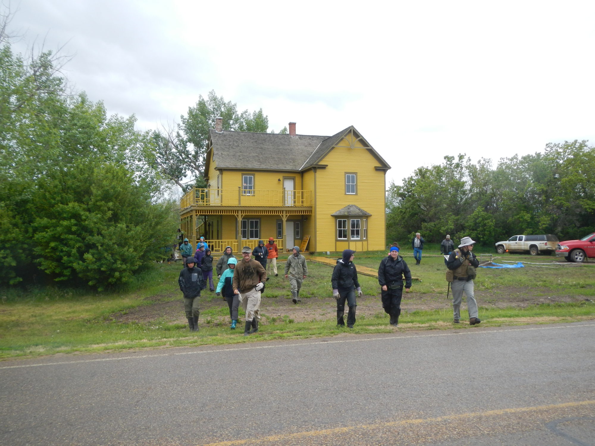


